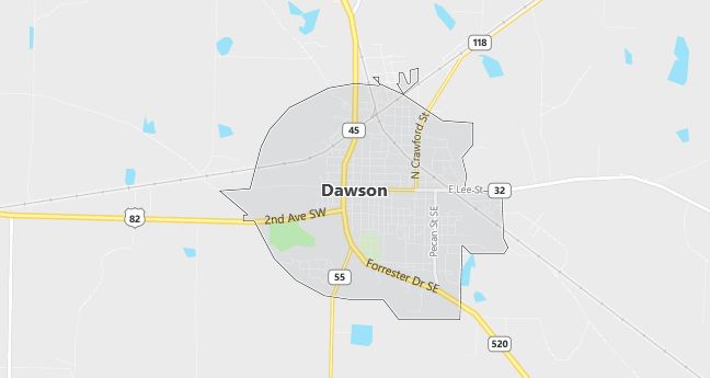
Moving to Dawson, Georgia
Dawson, incorporated on December 22, 1857, is the county seat of Terrell County. It was named in honor of William C. Dawson, jurist, congressman and U.S. Senator.
Shortly after Atlanta’s capture in the Civil War, Governor Joseph E. Brown arranged for a refugee camp at Dawson to shelter some 300 women and children who had fled the city. The “Exile Camp” was later used to house a detachment of 50 Union soldiers assigned to keep order in the area. Their kind behavior toward local citizens was long noted by the community.
Dawson has two sites listed on the National Register of Historic Places. These are the Terrell County courthouse and the Garden Club House.
The City of Dawson is the birthplace of rhythm and blues singer Otis Redding.
Population: 5,058. Estimated population in July 2024: 4,859 (-3.9% change)
Males: 2,298 (45.4%), Females: 2,760 (54.6%)
Terrell County
Zip code: 31742
Demographics
Median resident age: 33.1 years
Median household income: $24,140
Median house value: $54,800
Population by Race
Races in Dawson:
- Black (77.3%)
- White Non-Hispanic (21.2%)
- Hispanic (0.9%)
- Two or more races (0.7%)
Ancestries: United States (4.7%), English (4.7%), Irish (3.3%), Scotch-Irish (1.6%), German (1.1%).
Elevation: 355 feet
Land area: 3.7 square miles

Population by Education
For population 25 years and over in Dawson
- High school or higher: 60.6%
- Bachelor’s degree or higher: 8.9%
- Graduate or professional degree: 4.1%
- Unemployed: 11.7%
- Mean travel time to work: 19.3 minutes
For population 15 years and over in Dawson city
- Never married: 39.4%
- Now married: 35.4%
- Separated: 6.3%
- Widowed: 11.3%
- Divorced: 7.7%
1.7% Foreign born
Population change in the 1990s: -431 (-7.9%).
Hospitals
Hospitals/medical centers near Dawson:
- PHOEBE PUTNEY MEMORIAL HOSPITAL (about 23 miles; ALBANY, GA)
- SOUTHWEST GEORGIA REGIONAL MEDICAL CTR (about 23 miles; CUTHBERT, GA)
- HCA PALMYRA MEDICAL CENTERS (about 24 miles; ALBANY, GA)
Airports
Airports certified for carrier operations nearest to Dawson:
- SOUTHWEST GEORGIA REGIONAL (about 25 miles; ALBANY, GA; Abbreviation: ABY)
- LAWSON AAF (FORT BENNING) (about 54 miles; FORT BENNING(COLUMBUS), GA; Abbreviation: LSF)
- COLUMBUS METROPOLITAN (about 61 miles; COLUMBUS, GA; Abbreviation: CSG)
Other public-use airports nearest to Dawson:
- DAWSON MUNI (about 4 miles; DAWSON, GA; Abbreviation: 16J)
- PETERSON FIELD (about 22 miles; PLAINS, GA; Abbreviation: 7A9)
- CUTHBERT-RANDOLPH (about 27 miles; CUTHBERT, GA; Abbreviation: 25J)
Colleges and Universities
Colleges/universities with over 2000 students nearest to Dawson:
- ALBANY STATE UNIVERSITY (about 29 miles; ALBANY, GA; Full-time enrollment: 2,996)
- COLUMBUS STATE UNIVERSITY (about 59 miles; COLUMBUS, GA; Full-time enrollment: 3,886)
- FORT VALLEY STATE UNIVERSITY (about 66 miles; FT VALLEY, GA; Full-time enrollment: 2,233)
- GEORGE C WALLACE STATE COMMUNITY COLLEGE-DOTHAN (about 76 miles; DOTHAN, AL; Full-time enrollment: 2,703)
- MACON STATE COLLEGE (about 89 miles; MACON, GA; Full-time enrollment: 2,557)
- CENTRAL GEORGIA TECHNICAL COLLEGE (about 89 miles; MACON, GA; Full-time enrollment: 2,383)
- GORDON COLLEGE (about 91 miles; BARNESVILLE, GA; Full-time enrollment: 2,263)
Private high school in Dawson:
- TERRELL ACADEMY (Students: 307; Location: 602 ACADEMY DRIVE SE; Grades: PK – 12)
Public primary/middle schools in Dawson:
- TERRELL COUNTY MIDDLE/HIGH SCHOOL (Students: 830; Location: 488 CRAWFORD STREET, NE; Grades: 06 – 12)
- COOPER PRIMARY SCHOOL (Students: 471; Location: 1051 AUGUSTA STREET; Grades: PK – 02)
- CARVER ELEMENTARY SCHOOL (Students: 375; Location: 761 FIRST AVENUE, SE; Grades: 03 – 05)
Libraries
Library in Dawson:
- KINCHAFOONEE REGIONAL LIBRARY SYSTEM (Operating income: $709,928; Location: 913 FORRESTER DRIVE SE; 111,717 books; 804 audio materials; 5,159 video materials; 173 serial subscriptions)
