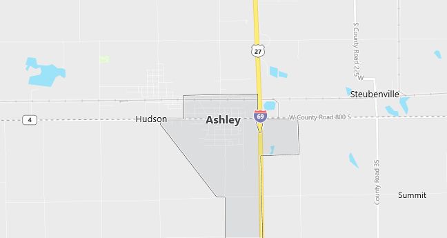
Moving to Ashley, Indiana
The current estimated population of Ashley, Indiana, is 1,000, with approximately 49% male and 51% female. The population has remained stable, reflecting the town’s small size and rural economy.
City Facts
- Year Founded: 1890
- County Affiliated: DeKalb and Steuben Counties
- Land Area: 1.7 square miles
- Population Density: 588 people per square mile
- Area Code: 260
- Zip Codes: 46705
Geography and Location
Ashley, Indiana, is located in northeastern Indiana, within DeKalb and Steuben Counties, about 35 miles north of Fort Wayne. Ashley experiences a humid continental climate, with cold winters and warm summers, typical of the Great Lakes region. The surrounding geography consists of flat farmland and small forests, with agriculture being the primary economic driver. The town is located near Interstate 69, providing easy access to nearby towns and cities. Ashley’s rural charm and proximity to larger cities like Fort Wayne make it an appealing place for those seeking a quiet, small-town lifestyle in northern Indiana.
Demographics
Median resident age: 30.3 years
Median household income: $35,893
Median house value: $70,200
Population by Race
Races in Ashley:
- White Non-Hispanic (96.8%)
- Two or more races (1.2%)
- Hispanic (1.0%)
- American Indian (0.9%)
Ancestries: German (27.6%), United States (12.1%), English (11.9%), Irish (6.3%), French (1.6%), Italian (1.4%).
Elevation: 1000 feet
Land area: 0.8 square miles

Population by Education
For population 25 years and over in Ashley
- High school or higher: 80.0%
- Bachelor’s degree or higher: 3.1%
- Graduate or professional degree: 1.0%
- Unemployed: 4.3%
- Mean travel time to work: 18.6 minutes
For population 15 years and over in Ashley town
- Never married: 25.2%
- Now married: 53.5%
- Separated: 2.7%
- Widowed: 3.7%
- Divorced: 14.9%
1.5% Foreign born
Population change in the 1990s: +245 (+32.0%).
Hospitals
Hospitals/medical centers near Ashley:
- CAMERON MEMORIAL COMMUNITY HOSPITAL (about 10 miles; ANGOLA, IN)
- DEKALB MEMORIAL HOSPITAL INC (about 12 miles; AUBURN, IN)
- PARKVIEW NOBLE HOSPITAL (about 15 miles; KENDALLVILLE, IN)
Airports
Airports certified for carrier operations nearest to Ashley:
- FORT WAYNE INTERNATIONAL (about 40 miles; FORT WAYNE, IN; Abbreviation: FWA)
- W K KELLOGG (about 55 miles; BATTLE CREEK, MI; Abbreviation: BTL)
- KALAMAZOO/BATTLE CREEK INTERNATIONAL (about 60 miles; KALAMAZOO, MI; Abbreviation: AZO)
Other public-use airports nearest to Ashley:
- TRI-STATE STEUBEN COUNTY (about 8 miles; ANGOLA, IN; Abbreviation: ANQ)
- WALKER/ROWE WATERLOO (about 11 miles; WATERLOO, IN; Abbreviation: 4C2)
- HARROLD (about 13 miles; BUTLER, IN; Abbreviation: B25)
Amtrak station near Ashley:
- 8 miles: WATERLOO (LINCOLN & CENTER STS.). Services: public payphones, free short-term parking, free long-term parking.
Colleges and Universities
Colleges/universities with over 2000 students nearest to Ashley:
- INDIANA UNIVERSITY-PURDUE UNIVERSITY-FORT WAYNE (about 30 miles; FT WAYNE, IN; Full-time enrollment: 7,385)
- KELLOGG COMMUNITY COLLEGE (about 58 miles; BATTLE CREEK, MI; Full-time enrollment: 2,824)
- SPRING ARBOR UNIVERSITY (about 59 miles; SPRING ARBOR, MI; Full-time enrollment: 2,266)
- WESTERN MICHIGAN UNIVERSITY (about 64 miles; KALAMAZOO, MI; Full-time enrollment: 23,132)
- KALAMAZOO VALLEY COMMUNITY COLLEGE (about 68 miles; KALAMAZOO, MI; Full-time enrollment: 5,017)
- JACKSON COMMUNITY COLLEGE (about 69 miles; JACKSON, MI; Full-time enrollment: 2,756)
- INDIANA WESLEYAN UNIVERSITY (about 80 miles; MARION, IN; Full-time enrollment: 6,684)
Public primary/middle school in Ashley:
- COUNTRY MEADOW ELEM SCHOOL (Students: 376; Location: 2410 CR 10; Grades: KG – 05)
