Moving to Adair, Iowa
The current estimated population of Adair, Iowa is 774, with 48.7% male and 51.3% female. The population of Adair has remained relatively stable in recent years, reflecting its small-town, rural character, with some fluctuation due to local employment opportunities and agricultural trends.
City Facts
- Year founded: 1872
- County: Adair
- Land area: 0.97 square miles
- Population density: Approximately 798 people per square mile
- Area code: 641
- Zip code: 50002
Geography and Location
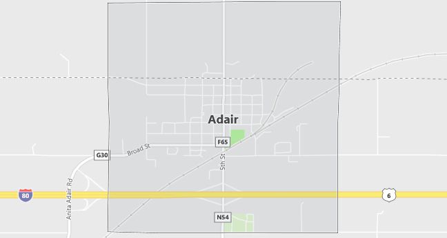
Adair, Iowa is located in western Iowa, along Interstate 80, providing easy access to both Des Moines and Omaha. It is part of Adair County and lies within a predominantly agricultural region. The surrounding area is mostly flat with large fields of corn and soybeans, reflecting the town’s strong agricultural roots. Adair is known for its rural charm and small-town appeal, with a close-knit community and a few local businesses serving the town’s needs. The town’s location on a major interstate makes it a convenient stop for travelers, while its quiet environment and scenic farmland views offer a peaceful way of life for residents.
Demographics
Median resident age: 42.9 years
Median household income: $31,319
Median house value: $53,600
Population by Race
Races in Adair:
- White Non-Hispanic (98.1%)
- Hispanic (1.2%)
Ancestries: German (37.3%), United States (12.9%), English (9.7%), Danish (9.4%), Irish (6.0%), Norwegian (5.1%).
Elevation: 1460 feet
Land area: 2.2 square miles

Population by Education
For population 25 years and over in Adair
- High school or higher: 85.1%
- Bachelor’s degree or higher: 13.4%
- Graduate or professional degree: 2.7%
- Unemployed: 2.0%
- Mean travel time to work: 18.0 minutes
For population 15 years and over in Adair city
- Never married: 15.2%
- Now married: 62.9%
- Separated: 0.3%
- Widowed: 14.1%
- Divorced: 7.5%
1.3% Foreign born
Population change in the 1990s: -53 (-5.9%).
Hospitals
Hospitals/medical centers near Adair:
- GUTHRIE COUNTY HOSPITAL (about 16 miles; GUTHRIE CENTER, IA)
- ADAIR COUNTY MEMORIAL HOSPITAL (about 21 miles; GREENFIELD, IA)
- AUDUBON COUNTY MEMORIAL HOSPITAL (about 26 miles; AUDUBON, IA)
Airports
Airports certified for carrier operations nearest to Adair:
- DES MOINES INTL (about 69 miles; DES MOINES, IA; Abbreviation: DSM)
- FORT DODGE REGIONAL (about 79 miles; FORT DODGE, IA; Abbreviation: FOD)
- EPPLEY AIRFIELD (about 87 miles; OMAHA, NE; Abbreviation: OMA)
Other public-use airports nearest to Adair:
- ANITA MUNI-KEVIN BURKE MEMORIAL FIELD (about 10 miles; ANITA, IA; Abbreviation: Y43)
- GUTHRIE COUNTY REGIONAL (about 20 miles; GUTHRIE CENTER, IA; Abbreviation: GCT)
- GREENFIELD MUNI (about 20 miles; GREENFIELD, IA; Abbreviation: GFZ)
Colleges and Universities
Colleges/universities with over 2000 students nearest to Adair:
- DRAKE UNIVERSITY (about 67 miles; DES MOINES, IA; Full-time enrollment: 4,227)
- DES MOINES COMMUNITY COLLEGE (about 74 miles; ANKENY, IA; Full-time enrollment: 6,959)
- IOWA CENTRAL COMMUNITY COLLEGE (about 76 miles; FT DODGE, IA; Full-time enrollment: 2,807)
- GRACELAND UNIVERSITY-LAMONI (about 77 miles; LAMONI, IA; Full-time enrollment: 2,026)
- NORTHWEST MISSOURI STATE UNIVERSITY (about 82 miles; MARYVILLE, MO; Full-time enrollment: 5,620)
- IOWA WESTERN COMMUNITY COLLEGE (about 82 miles; COUNCIL BLUFFS, IA; Full-time enrollment: 2,840)
- BUENA VISTA UNIVERSITY (about 88 miles; STORM LAKE, IA; Full-time enrollment: 2,524)
Schools
Public high school in Adair:
- ADAIR-CASEY JR-SR HIGH SCHOOL (Students: 174; Location: 3384 INDIGO AVE; Grades: 07 – 12)
Public primary/middle school in Adair:
- ADAIR-CASEY ELEMENTARY SCHOOL (Students: 184; Location: 3384 INDIGO AVE.; Grades: KG – 06)
Libraries
Library in Adair:
- ADAIR PUBLIC LIBRARY (Operating income: $16,045; Location: 310 AUDUBON; 10,042 books; 19 audio materials; 118 video materials; 40 serial subscriptions)
