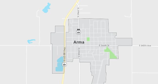
Arma, Kansas Population, Hospitals, Airports, and Schools
The current estimated population of Arma is 1,400, with a gender distribution of 49% male and 51% female. The population has remained relatively stable, supported by its agricultural base and small-town atmosphere in southeastern Kansas.
City Facts
- Year founded: 1894
- County: Crawford County
- Land area: 1.1 square miles
- Population density: 1,273 people per square mile
- Area code: 620
- Zip code: 66712
Geography and Location
Arma is a small town located in Crawford County, in southeastern Kansas, about 7 miles north of Pittsburg. The town is situated in a rural area known for its coal mining history, although agriculture now plays a significant role in the local economy. Arma experiences a humid subtropical climate, with hot summers and mild winters. U.S. Route 69 runs just east of the town, providing connections to Pittsburg and other nearby towns. The local economy is driven by small businesses, agriculture, and services for the surrounding rural community. Arma’s small size, peaceful atmosphere, and community events, such as the annual Arma VJ Homecoming celebration, contribute to its appeal as a close-knit, rural town in Kansas.
Demographics
Median resident age: 42.0 years
Median household income: $26,658
Median house value: $50,100
Population by Race
Races in Arma:
- White Non-Hispanic (96.9%)
- American Indian (1.1%)
- Two or more races (1.0%)
- Hispanic (0.9%)
Ancestries: German (19.0%), Italian (12.3%), Irish (12.0%), English (9.7%), United States (8.1%), French (6.7%).
Elevation: 1003 feet
Land area: 1.0 square miles

Population by Education
For population 25 years and over in Arma
- High school or higher: 80.2%
- Bachelor’s degree or higher: 14.7%
- Graduate or professional degree: 3.8%
- Unemployed: 5.2%
- Mean travel time to work: 22.9 minutes
For population 15 years and over in Arma city
- Never married: 18.4%
- Now married: 57.6%
- Separated: 1.3%
- Widowed: 11.3%
- Divorced: 11.5%
0.1% Foreign born
Population change in the 1990s: +4 (+0.3%).
Hospitals
Hospitals/medical centers near Arma:
- MT CARMEL MEDICAL CENTER (about 10 miles; PITTSBURG, KS)
- HOSPITAL DISTRICT 1 CRAWFORD COUNTY (about 12 miles; GIRARD, KS)
- MERCY HOSPITAL (about 20 miles; FORT SCOTT, KS)
Airports
Airports certified for carrier operations nearest to Arma:
- JOPLIN REGIONAL (about 31 miles; JOPLIN, MO; Abbreviation: JLN)
- NORTHWEST ARKANSAS RGNL (about 93 miles; FAYETTEVILLE/SPRINGDALE/, AR; Abbreviation: XNA)
- SPRINGFIELD-BRANSON REGIONAL (about 94 miles; SPRINGFIELD, MO; Abbreviation: SGF)
Other public-use airports nearest to Arma:
- ATKINSON MUNI (about 8 miles; PITTSBURG, KS; Abbreviation: PTS)
- FORT SCOTT MUNI (about 18 miles; FORT SCOTT, KS; Abbreviation: FSK)
- LAMAR MUNI (about 29 miles; LAMAR, MO; Abbreviation: LLU)
Colleges and Universities
Colleges/universities with over 2000 students nearest to Arma:
- PITTSBURG STATE UNIVERSITY (about 10 miles; PITTSBURG, KS; Full-time enrollment: 5,566)
- MISSOURI SOUTHERN STATE COLLEGE (about 34 miles; JOPLIN, MO; Full-time enrollment: 4,569)
- NORTHWEST ARKANSAS COMMUNITY COLLEGE (about 88 miles; BENTONVILLE, AR; Full-time enrollment: 2,197)
- SOUTHWEST BAPTIST UNIVERSITY (about 91 miles; BOLIVAR, MO; Full-time enrollment: 2,612)
- JOHNSON COUNTY COMMUNITY COLLEGE (about 95 miles; OVERLAND PARK, KS; Full-time enrollment: 8,857)
- OZARKS TECHNICAL COMMUNITY COLLEGE (about 96 miles; SPRINGFIELD, MO; Full-time enrollment: 3,756)
- METROPOLITAN COMMUNITY COLLEGE (about 97 miles; LEES SUMMIT, MO; Full-time enrollment: 4,576)
Schools
Public high school in Arma:
- NORTH EAST HIGH (Students: 189; Location: 1003 E SOUTH STREET; Grades: 09 – 12)
Public primary/middle school in Arma:
- NORTHEAST ELEM (Students: 387; Location: 201 NORTH WEST STREET; Grades: PK – 08)
Libraries
Library in Arma:
- ARMA CITY LIBRARY (Operating income: $21,648; Location: 501 NORTH WEST STREET; 5,988 books; 208 audio materials; 293 video materials; 28 serial subscriptions)
