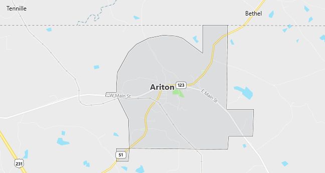
Moving to Ariton, Alabama
The current estimated population of Ariton, Alabama, is 730, with approximately 48% male and 52% female. The population has remained stable, reflecting the town’s small size and rural setting.
City Facts
- Year Founded: 1906
- County Affiliated: Dale County
- Land Area: 6.1 square miles
- Population Density: 120 people per square mile
- Area Code: 334
- Zip Codes: 36311
Geography and Location
Ariton, Alabama, is a small town located in southeastern Alabama, within Dale County. The town is situated about 25 miles northwest of Dothan, providing access to a larger city while maintaining a quiet, rural atmosphere. Ariton experiences a humid subtropical climate, with hot, humid summers and mild winters, typical of the southeastern United States. The surrounding geography consists of flat to gently rolling farmland and forests, with agricultural activities being a key part of the local economy. The town is located along Alabama State Route 123, making it easily accessible from nearby communities. Ariton’s small size, strong community ties, and rural charm make it a peaceful place to live, with local schools, churches, and community events supporting its residents.
Demographics
Median resident age: 35.9 years
Median household income: $21,083
Median house value: $55,000
Population by Race
Races in Ariton:
- White Non-Hispanic (69.3%)
- Black (29.3%)
- Two or more races (1.3%)
- American Indian (0.9%)
- Hispanic (0.8%)
Ancestries: United States (44.3%), German (4.1%), Irish (4.0%), English (3.5%), Italian (1.8%), French (1.6%).
Elevation: 460 feet
Land area: 5.1 square miles

Population by Education
For population 25 years and over in Ariton
- High school or higher: 62.8%
- Bachelor’s degree or higher: 9.4%
- Graduate or professional degree: 3.4%
- Unemployed: 8.0%
- Mean travel time to work: 24.5 minutes
For population 15 years and over in Ariton town
- Never married: 22.7%
- Now married: 54.2%
- Separated: 4.5%
- Widowed: 11.2%
- Divorced: 7.5%
0.0% Foreign born
Population change in the 1990s: +11 (+1.4%).
Hospitals
Hospitals/medical centers near Ariton:
- DALE MED CTR GER PSY UNIT NEW DAY SENI (about 13 miles; OZARK, AL)
- MEDICAL CENTER ENTERPRISE (about 21 miles; ENTERPRISE, AL)
- EDGE REGIONAL MEDICAL CENTER (about 23 miles; TROY, AL)
Airports
Airports certified for carrier operations nearest to Ariton:
- DOTHAN RGNL (about 28 miles; DOTHAN, AL; Abbreviation: DHN)
- MONTGOMERY RGNL (DANNELLY FIELD) (about 67 miles; MONTGOMERY, AL; Abbreviation: MGM)
- LAWSON AAF (FORT BENNING) (about 72 miles; FORT BENNING(COLUMBUS), GA; Abbreviation: LSF)
Other public-use airports nearest to Ariton:
- BRUNDIDGE MUNI (about 11 miles; BRUNDIDGE, AL; Abbreviation: 60A)
- BLACKWELL FIELD (about 15 miles; OZARK, AL; Abbreviation: 71J)
- LOWE AHP (FORT RUCKER) (about 18 miles; FORT RUCKER OZARK, AL; Abbreviation: LOR)
Colleges and Universities
Colleges/universities with over 2000 students nearest to Ariton:
- TROY STATE UNIVERSITY-MAIN CAMPUS (about 23 miles; TROY, AL; Full-time enrollment: 9,143)
- GEORGE C WALLACE STATE COMMUNITY COLLEGE-DOTHAN (about 33 miles; DOTHAN, AL; Full-time enrollment: 2,703)
- AUBURN UNIVERSITY-MONTGOMERY (about 56 miles; MONTGOMERY, AL; Full-time enrollment: 3,677)
- TUSKEGEE UNIVERSITY (about 57 miles; TUSKEGEE, AL; Full-time enrollment: 2,732)
- ALABAMA STATE UNIVERSITY (about 65 miles; MONTGOMERY, AL; Full-time enrollment: 4,359)
- FAULKNER UNIVERSITY (about 66 miles; MONTGOMERY, AL; Full-time enrollment: 2,283)
- COMMUNITY COLLEGE OF THE AIR FORCE (about 69 miles; MONTGOMERY, AL; Full-time enrollment: 126,963)
Public primary/middle school in Ariton:
- ARITON SCHOOL (Students: 619; Location: #264 CREEL RICHARDSON RD.; Grades: KG – 12)
Libraries
Library in Ariton:
- DOT LANEY MEMORIAL LIBRARY (Operating income: $13,974; Location: 30 WEST MAIN STREET; 5,362 books; 45 audio materials; 179 video materials)
