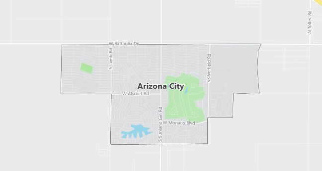
Moving to Arizona City, Arizona
The current estimated population of Arizona City, Arizona, is 11,817, with approximately 51% male and 49% female. The population has grown rapidly due to suburban expansion and affordable housing options.
City Facts
- Year Founded: 1959
- County Affiliated: Pinal County
- Land Area: 6.4 square miles
- Population Density: 1,846 people per square mile
- Area Code: 520
- Zip Codes: 85123
Geography and Location
Arizona City, Arizona, is a growing suburban community located in south-central Arizona, within Pinal County. It is situated approximately halfway between Phoenix and Tucson, making it an attractive location for commuters seeking more affordable housing options. Arizona City experiences a desert climate, with extremely hot summers and mild winters, typical of Arizona’s low desert regions. The town is located near Interstate 10, providing easy access to larger urban centers like Phoenix and Tucson. The surrounding geography is characterized by flat desert land, with views of distant mountain ranges such as the Sawtooth and Picacho Mountains. The town is built around a man-made lake, offering recreational opportunities such as boating and fishing. Arizona City has seen significant growth in recent years due to its location, affordability, and expanding suburban development.
Demographics
Median resident age: 41.1 years
Median household income: $37,432
Median house value: $85,000
Population by Race
Races in Arizona City:
- White Non-Hispanic (78.2%)
- Hispanic (16.6%)
- Other race (8.1%)
- American Indian (3.4%)
- Two or more races (2.6%)
- Black (1.1%)
(Total can be greater than 100% because Hispanics could be counted in other races)
Ancestries: German (15.5%), English (10.1%), Irish (9.2%), United States (7.5%), French (4.4%), Italian (3.8%).
Elevation: 1510 feet
Land area: 6.1 square miles

Population by Education
For population 25 years and over in Arizona City
- High school or higher: 83.8%
- Bachelor’s degree or higher: 11.7%
- Graduate or professional degree: 3.7%
- Unemployed: 4.1%
- Mean travel time to work: 27.4 minutes
For population 15 years and over in Arizona City CDP
- Never married: 16.9%
- Now married: 67.8%
- Separated: 0.8%
- Widowed: 6.2%
- Divorced: 8.4%
3.0% Foreign born (1.9% Latin America, 0.4% Europe, 0.4% Asia).
Hospitals
Hospitals/medical centers near Arizona City:
- CASA GRANDE REGIONAL MEDICAL CENTER (about 10 miles; CASA GRANDE, AZ)
- HU HU KAM MEMORIAL HOSPITAL (about 25 miles; SACATON, AZ)
- CHANDLER REGIONAL HOSPITAL (about 42 miles; CHANDLER, AZ)
Airports
Airports certified for carrier operations nearest to Arizona City:
- PINAL AIRPARK (about 31 miles; MARANA, AZ; Abbreviation: MZJ)
- WILLIAMS GATEWAY (about 38 miles; PHOENIX, AZ; Abbreviation: IWA)
- PHOENIX SKY HARBOR INTL (about 52 miles; PHOENIX, AZ; Abbreviation: PHX)
Other public-use airports nearest to Arizona City:
- ELOY MUNI (about 8 miles; ELOY, AZ; Abbreviation: E60)
- CASA GRANDE MUNI (about 15 miles; CASA GRANDE, AZ; Abbreviation: CGZ)
- COOLIDGE MUNI (about 23 miles; COOLIDGE, AZ; Abbreviation: P08)
Colleges and Universities
Colleges/universities with over 2000 students nearest to Arizona City:
- CENTRAL ARIZONA COLLEGE (about 19 miles; COOLIDGE, AZ; Full-time enrollment: 2,333)
- CHANDLER/GILBERT COMMUNITY COLLEGE (about 41 miles; CHANDLER, AZ; Full-time enrollment: 2,990)
- MESA COMMUNITY COLLEGE (about 46 miles; MESA, AZ; Full-time enrollment: 11,928)
- RIO SALADO COMMUNITY COLLEGE (about 50 miles; TEMPE, AZ; Full-time enrollment: 4,472)
- AL COLLINS GRAPHIC DESIGN SCHOOL LTD (about 50 miles; TEMPE, AZ; Full-time enrollment: 4,057)
- ARIZONA STATE UNIVERSITY-MAIN CAMPUS (about 50 miles; TEMPE, AZ; Full-time enrollment: 37,174)
- UNIVERSITY OF PHOENIX-PHOENIX CAMPUS (about 51 miles; PHOENIX, AZ; Full-time enrollment: 9,152)
Public primary/middle school in Arizona City:
- TOLTEC ELEMENTARY SCHOOL (Students: 601; Location: 12115 W. BENITO ROAD; Grades: PK – 04)
