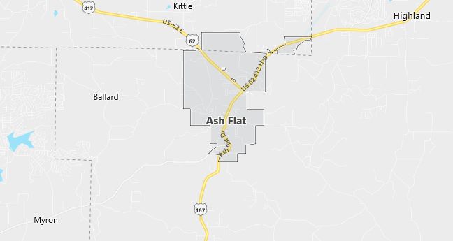
Moving to Ash Flat, Arkansas
The current estimated population of Ash Flat is 1,100, with a gender distribution of 48% male and 52% female. The population has remained stable, supported by its role as a small regional hub in northern Arkansas.
City Facts
- Year founded: 1856
- County: Sharp County and Fulton County
- Land area: 5.8 square miles
- Population density: 189 people per square mile
- Area code: 870
- Zip code: 72513
Geography and Location
Ash Flat is located in northern Arkansas, serving as the county seat of Sharp County. The town is situated in the Ozark Mountain foothills, providing scenic, rolling landscapes typical of the region. Ash Flat has a humid subtropical climate, with hot, humid summers and mild winters. U.S. Route 62 and U.S. Route 412 intersect in Ash Flat, making it an important crossroads for travelers and locals alike. The local economy is largely supported by small businesses, agriculture, and services catering to the surrounding rural areas. With its combination of rural charm, natural beauty, and access to essential services, Ash Flat is a small but vital community in northern Arkansas.
Demographics
Median resident age: 46.8 years
Median household income: $16,797
Median house value: $50,500
Population by Race
Races in Ash Flat:
- White Non-Hispanic (98.0%)
- American Indian (0.8%)
- Two or more races (0.8%)
- Hispanic (0.7%)
Ancestries: United States (22.5%), German (20.2%), Irish (13.0%), English (4.8%), French (3.1%), Italian (2.5%).
Elevation: 662 feet
Land area: 5.6 square miles

Population by Education
For population 25 years and over in Ash Flat
- High school or higher: 69.8%
- Bachelor’s degree or higher: 14.0%
- Graduate or professional degree: 1.7%
- Unemployed: 9.0%
- Mean travel time to work: 21.2 minutes
For population 15 years and over in Ash Flat city
- Never married: 18.6%
- Now married: 54.6%
- Separated: 1.4%
- Widowed: 13.4%
- Divorced: 12.1%
0.8% Foreign born
Population change in the 1990s: +268 (+37.8%)
Hospitals
Hospitals/medical centers near Ash Flat:
- EASTERN OZARKS REGIONAL HEALTH SYSTEM (about 6 miles; CHEROKEE VILLAGE, AR)
- FULTON COUNTY HOSPITAL (about 18 miles; SALEM, AR)
- WHITE RIVER MEDICAL CENTER (about 35 miles; BATESVILLE, AR)
Airports
Airports certified for carrier operations nearest to Ash Flat:
- LITTLE ROCK AFB (about 99 miles; JACKSONVILLE, AR; Abbreviation: LRF)
- WAYNESVILLE RGNL ARPT AT FORNEY FIELD (about 110 miles; FORT LEONARD WOOD, MO; Abbreviation: TBN)
- ADAMS FIELD (about 113 miles; LITTLE ROCK, AR; Abbreviation: LIT)
Other public-use airports nearest to Ash Flat:
- SHARP COUNTY REGIONAL (about 5 miles; ASH FLAT, AR; Abbreviation: CVK)
- HORSESHOE BEND (about 10 miles; HORSESHOE BEND, AR; Abbreviation: 6M2)
- SALEM (about 17 miles; SALEM, AR; Abbreviation: 7M9)
Colleges and Universities
Colleges/universities with over 2000 students nearest to Ash Flat:
- HARDING UNIVERSITY (about 69 miles; SEARCY, AR; Full-time enrollment: 3,959)
- ARKANSAS STATE UNIVERSITY-MAIN CAMPUS (about 70 miles; STATE UNIVERSITY, AR; Full-time enrollment: 8,696)
- ARKANSAS STATE UNIVERSITY-BEEBE BRANCH (about 81 miles; BEEBE, AR; Full-time enrollment: 3,840)
- UNIVERSITY OF CENTRAL ARKANSAS (about 93 miles; CONWAY, AR; Full-time enrollment: 7,693)
- UNIVERSITY OF MISSOURI-ROLLA (about 114 miles; ROLLA, MO; Full-time enrollment: 4,181)
- UNIVERSITY OF ARKANSAS AT LITTLE ROCK (about 115 miles; LITTLE ROCK, AR; Full-time enrollment: 8,024)
- ARKANSAS TECH UNIVERSITY (about 125 miles; RUSSELLVILLE, AR; Full-time enrollment: 4,450)
