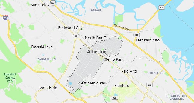
Moving to Atherton, California
The current estimated population of Atherton is 7,200, with males comprising 48% and females 52%. The population has remained relatively stable due to its exclusive residential character and high property values, which attract affluent residents.
City Facts
- Year Founded: 1923
- County Affiliated: San Mateo County
- Land Area: 5.0 square miles
- Population Density: 1,440 people per square mile
- Area Code: 650
- Zip Codes: 94027
Geography and Location
Atherton is an affluent residential town located on the San Francisco Peninsula, approximately 30 miles south of San Francisco and 20 miles north of San Jose. The town is known for its expansive estates, tree-lined streets, and lack of commercial development, which preserves its quiet, suburban feel. Atherton is bordered by Menlo Park, Redwood City, and Palo Alto, placing it in the heart of Silicon Valley while maintaining a sense of exclusivity and tranquility. The town experiences a Mediterranean climate, with warm, dry summers and mild, wet winters. Atherton’s proximity to major tech hubs makes it a desirable location for wealthy individuals and executives, many of whom work in the technology industry. Despite its small size, Atherton is home to some of the wealthiest residents in the United States, and its zoning regulations strictly limit commercial development and high-density housing, preserving its character as a quiet, upscale community. The town’s lush landscaping, large properties, and access to excellent schools and amenities make it a highly desirable place to live.
Demographics
Median resident age: 45.3 years
Median household income: $200,001
Median house value: $1,000,001
Population by Race
Races in Atherton:
- White Non-Hispanic (83.7%)
- Chinese (5.2%)
- Hispanic (2.8%)
- Two or more races (2.6%)
- Japanese (1.1%)
- Asian Indian (1.1%)
- Other race (1.0%)
- Filipino (0.8%)
- Other Asian (0.8%)
- Black (0.7%)
Ancestries: German (18.0%), English (15.5%), Irish (11.7%), Italian (9.5%), Scottish (5.7%), Swedish (3.8%).
Elevation: 60 feet
Land area: 4.9 square miles

Population by Education
For population 25 years and over in Atherton
- High school or higher: 96.7%
- Bachelor’s degree or higher: 76.2%
- Graduate or professional degree: 40.2%
- Unemployed: 2.0%
- Mean travel time to work: 23.2 minutes
For population 15 years and over in Atherton town
- Never married: 21.3%
- Now married: 66.3%
- Separated: 0.7%
- Widowed: 6.6%
- Divorced: 5.0%
14.3% Foreign born (7.4% Asia, 4.7% Europe).
Population change in the 1990s: +309 (+4.5%).
Hospitals
Hospitals/medical centers near Atherton:
- RECOVERY INN OF MENLO PARK (about 2 miles; MENLO PARK, CA)
- KAISER FOUNDATION HOSPITAL (about 2 miles; REDWOOD CITY, CA)
- STANFORD HOSPITAL (about 4 miles; STANFORD, CA)
Airports
Airports certified for carrier operations nearest to Atherton:
- SAN FRANCISCO INTERNATIONAL (about 16 miles; SAN FRANCISCO, CA; Abbreviation: SFO)
- METROPOLITAN OAKLAND INTL (about 18 miles; OAKLAND, CA; Abbreviation: OAK)
- NORMAN Y. MINETA SAN JOSE INTERNATIONAL (about 21 miles; SAN JOSE, CA; Abbreviation: SJC)
Other public-use airports nearest to Atherton:
- SAN CARLOS (about 4 miles; SAN CARLOS, CA; Abbreviation: SQL)
- PALO ALTO ARPT OF SANTA CLARA CO (about 7 miles; PALO ALTO, CA; Abbreviation: PAO)
- HAYWARD EXECUTIVE (about 15 miles; HAYWARD, CA; Abbreviation: HWD)
Amtrak stations near Atherton:
- 16 miles: FREMONT (CENTERVILLE, FREMONT & PERALTA BLVDS.). Services: fully wheelchair accessible, enclosed waiting area, public restrooms, public payphones, snack bar, free short-term parking, free long-term parking, call for car rental service, call for taxi service, public transit connection.
- 16 miles: HAYWARD (22555 MEEKLAND AVE.). Services: fully wheelchair accessible, public payphones, free short-term parking.
- 17 miles: MILLBRAE (MILLBRAE AVE. & CALIFORNIA DR.) – Bus Station. Services: fully wheelchair accessible, public payphones, free short-term parking, call for taxi service, public transit connection.
Colleges and Universities
College/University in Atherton:
- MENLO COLLEGE (Full-time enrollment: 639; Location: 1000 EL CAMINO REAL; Private, not-for-profit; Website: www.menlo.edu)
Colleges and Universities
Colleges/universities with over 2000 students nearest to Atherton:
- CANADA COLLEGE (about 3 miles; REDWOOD CITY, CA; Full-time enrollment: 2,438)
- STANFORD UNIVERSITY (about 4 miles; STANFORD, CA; Full-time enrollment: 14,955)
- FOOTHILL COLLEGE (about 8 miles; LOS ALTOS HILLS, CA; Full-time enrollment: 7,415)
- COLLEGE OF SAN MATEO (about 11 miles; SAN MATEO, CA; Full-time enrollment: 5,619)
- CHABOT COLLEGE (about 14 miles; HAYWARD, CA; Full-time enrollment: 6,852)
- DE ANZA COLLEGE (about 15 miles; CUPERTINO, CA; Full-time enrollment: 13,197)
- CALIFORNIA STATE UNIVERSITY-HAYWARD (about 18 miles; HAYWARD, CA; Full-time enrollment: 9,988)
Schools
Public high school in Atherton:
- MENLO-ATHERTON HIGH (Students: 2,090; Location: 555 MIDDLEFIELD ROAD; Grades: 09 – 12)
Private high schools in Atherton:
- MENLO SCHOOL (Students: 752; Location: 50 VALPARAISO AVE; Grades: 6 – 12)
- SACRED HEART PREPARATORY (Students: 430; Location: 150 VALPARAISO AVENUE; Grades: 9 – 12)
Public primary/middle schools in Atherton:
- SELBY LANE ELEMENTARY (Students: 610; Location: 170 SELBY LANE; Grades: KG – 08)
- LAS LOMITAS ELEMENTARY (Students: 465; Location: 299 ALAMEDA DE LAS PULGAS; Grades: KG – 03)
- LAUREL ELEMENTARY (Students: 406; Location: 95 EDGE ROAD; Grades: KG – 02)
- ENCINAL ELEMENTARY (Students: 344; Location: 195 ENCINAL AVE.; Grades: 03 – 05)
Private primary/middle school in Atherton:
- ST JOSEPH ELEMENTARY SCHOOL (Students: 517; Location: 50 EMILIE AVENUE; Grades: PK – 8)
