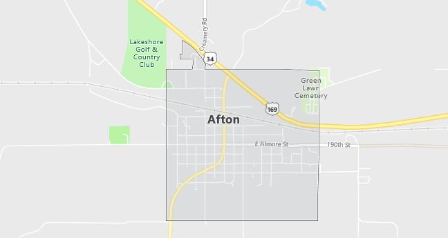
Moving to Afton, Iowa
The current estimated population of Afton, Iowa is 836, with 49.7% male and 50.3% female. Afton’s population has remained stable over the years, reflecting its status as a small, rural town with a close-knit community.
City Facts
- Year founded: 1854
- County: Union
- Land area: 0.96 square miles
- Population density: Approximately 871 people per square mile
- Area code: 641
- Zip code: 50830
Geography and Location
Afton, Iowa is located in southwestern Iowa, in Union County. The town is situated near U.S. Highway 34, providing access to larger nearby towns such as Creston. Afton is surrounded by a mix of farmland and small wooded areas, characteristic of rural Iowa. The town serves as a local hub for the surrounding farming community, offering essential services, local shops, and schools. The rolling plains of Iowa define the landscape, making Afton a peaceful, rural environment with a strong agricultural heritage.
Demographics
Median resident age: 39.5 years
Median household income: $28,281
Median house value: $45,000
Population by Race
Races in Afton:
- White Non-Hispanic (97.7%)
- Hispanic (1.9%)
- Other race (0.9%)
Ancestries: German (24.8%), Irish (12.9%), United States (9.3%), English (7.9%), Norwegian (2.8%), Swedish (2.5%).
Elevation: 1240 feet
Land area: 1.0 square miles

Population by Education
For population 25 years and over in Afton
- High school or higher: 83.6%
- Bachelor’s degree or higher: 9.7%
- Graduate or professional degree: 3.0%
- Unemployed: 4.7%
- Mean travel time to work: 17.7 minutes
For population 15 years and over in Afton city
- Never married: 23.3%
- Now married: 56.1%
- Separated: 0.8%
- Widowed: 9.7%
- Divorced: 10.1%
1.7% Foreign born
Population change in the 1990s: -43 (-4.5%).
Hospitals
Hospitals/medical centers near Afton:
- GREATER COMMUNITY HOSPITAL (about 14 miles; CRESTON, IA)
- RINGGOLD COUNTY HOSPITAL (about 23 miles; MOUNT AYR, IA)
- MADISON COUNTY HOSPITAL (about 24 miles; WINTERSET, IA)
Airports
Airports certified for carrier operations nearest to Afton:
- DES MOINES INTL (about 52 miles; DES MOINES, IA; Abbreviation: DSM)
- ROSECRANS MEMORIAL (about 100 miles; ST JOSEPH, MO; Abbreviation: STJ)
- FORT DODGE REGIONAL (about 105 miles; FORT DODGE, IA; Abbreviation: FOD)
Other public-use airports nearest to Afton:
- CRESTON MUNI (about 11 miles; CRESTON, IA; Abbreviation: CSQ)
- JUDGE LEWIS FLD MT AYR MUNI (about 23 miles; MOUNT AYR, IA; Abbreviation: 1Y3)
- WINTERSET-MADISON COUNTY (about 26 miles; WINTERSET, IA; Abbreviation: 3Y3)
Amtrak station near Afton:
- 12 miles: CRESTON (PINE & ADAMS STS.). Services: partially wheelchair accessible, enclosed waiting area, public payphones, free short-term parking, free long-term parking, call for taxi service.
Colleges and Universities
Colleges/universities with over 2000 students nearest to Afton:
- GRACELAND UNIVERSITY-LAMONI (about 33 miles; LAMONI, IA; Full-time enrollment: 2,026)
- DRAKE UNIVERSITY (about 54 miles; DES MOINES, IA; Full-time enrollment: 4,227)
- DES MOINES COMMUNITY COLLEGE (about 64 miles; ANKENY, IA; Full-time enrollment: 6,959)
- NORTHWEST MISSOURI STATE UNIVERSITY (about 67 miles; MARYVILLE, MO; Full-time enrollment: 5,620)
- IOWA STATE UNIVERSITY (about 86 miles; AMES, IA; Full-time enrollment: 24,473)
- MISSOURI WESTERN STATE COLLEGE (about 98 miles; ST JOSEPH, MO; Full-time enrollment: 4,329)
- IOWA CENTRAL COMMUNITY COLLEGE (about 102 miles; FT DODGE, IA; Full-time enrollment: 2,807)
Public primary/middle schools in Afton:
- EAST UNION JUNIOR-SENIOR HIGH SCHOOL (Students: 265; Location: 1916 HIGH SCHOOL DR; Grades: 06 – 12)
- EAST UNION INTERMEDIATE CENTER (Students: 104; Location: 1916 HIGH SCHOOL DRIVE; Grades: 03 – 05)
- EAST UNION PRIMARY CENTER (Students: 80; Location: 205 S DOUGLAS; Grades: KG – 02)
