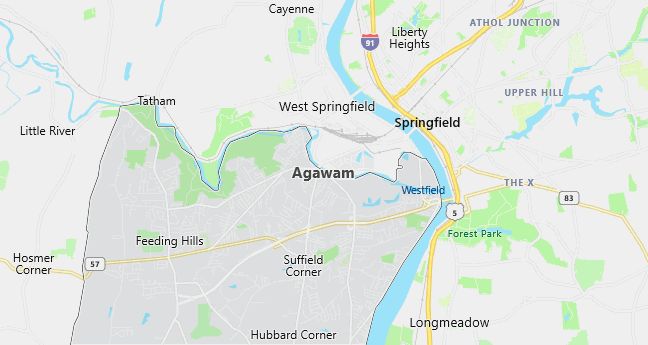
Moving to Agawam, Massachusetts
The current estimated population of Agawam, Massachusetts is 28,713, with 48.5% male and 51.5% female. Agawam has experienced steady growth over the years due to its proximity to Springfield and its desirable location near the Connecticut River.
City Facts
- Year founded: 1636
- County: Hampden
- Land area: 24.2 square miles
- Population density: Approximately 1,186 people per square mile
- Area code: 413
- Zip codes: 01001, 01030
Geography and Location
Agawam, Massachusetts is located in Hampden County, in the southwestern part of the state, on the western bank of the Connecticut River. The town is part of the Springfield metropolitan area and is situated just across the river from the city of Springfield. Agawam’s landscape is a mix of suburban neighborhoods, agricultural land, and natural parks. The town is home to Six Flags New England, a popular amusement park that draws visitors from across the region. The nearby Connecticut River offers scenic views and recreational opportunities like boating and fishing. Agawam’s convenient location near major highways, including Interstate 91, makes it an attractive residential community for commuters working in Springfield and other nearby cities.
Demographics
Median resident age: 40.3 years
Median household income: $49,390
Median house value: $132,000
Population by Race
Races in Agawam:
- White Non-Hispanic (95.5%)
- Hispanic (1.8%)
- Black (0.9%)
- Two or more races (0.8%)
Ancestries: Italian (23.6%), Irish (20.4%), French (17.2%), Polish (12.8%), English (10.6%), French Canadian (10.3%).
Elevation: 90 feet
Land area: 23.2 square miles

Population by Education
For population 25 years and over in Agawam
- High school or higher: 87.5%
- Bachelor’s degree or higher: 21.4%
- Graduate or professional degree: 6.4%
- Unemployed: 4.1%
- Mean travel time to work: 20.5 minutes
For population 15 years and over in Agawam city
- Never married: 24.9%
- Now married: 53.5%
- Separated: 1.8%
- Widowed: 9.7%
- Divorced: 10.1%
5.3% Foreign born (3.1% Europe, 1.1% Asia, 0.8% North America).
Population change in the 1990s: +816 (+3.0%).
Hospitals
Hospitals/medical centers near Agawam:
- BAYSTATE MEDICAL CENTER (about 5 miles; SPRINGFIELD, MA)
- MERCY HOSPITAL, INC (about 7 miles; SPRINGFIELD, MA)
- PARK VIEW SPECIALTY HOSPITAL (about 8 miles; SPRINGFIELD, MA)
Airports
Airports certified for carrier operations nearest to Agawam:
- BARNES MUNI (about 7 miles; WESTFIELD/SPRINGFIELD, MA; Abbreviation: BAF)
- BRADLEY INTL (about 10 miles; WINDSOR LOCKS, CT; Abbreviation: BDL)
- WESTOVER ARB/METROPOLITAN (about 11 miles; SPRINGFIELD/CHICOPEE, MA; Abbreviation: CEF)
Other public-use airports nearest to Agawam:
- SKYLARK AIRPARK (about 12 miles; WAREHOUSE POINT, CT; Abbreviation: 7B6)
- SIMSBURY (about 14 miles; SIMSBURY, CT; Abbreviation: 4B9)
- NORTHAMPTON (about 18 miles; NORTHAMPTON, MA; Abbreviation: 7B2)
Amtrak stations near Agawam:
- 5 miles: SPRINGFIELD (66 LYMAN ST.). Services: ticket office, partially wheelchair accessible, enclosed waiting area, public restrooms, public payphones, full-service food facilities, snack bar, vending machines, ATM, paid short-term parking, paid long-term parking, call for car rental service, taxi stand, intercity bus service, public transit connection.
- 11 miles: WINDSOR LOCKS (S. MAIN ST. (RTE. 159)). Services: public payphones, free short-term parking, free long-term parking, call for car rental service, call for taxi service, public transit connection.
- 16 miles: WINDSOR (41 CENTRAL ST.). Services: enclosed waiting area, public restrooms, public payphones, free short-term parking, call for car rental service, call for taxi service, public transit connection.
Colleges and Universities
Colleges/universities with over 2000 students nearest to Agawam:
- SPRINGFIELD TECHNICAL COMMUNITY COLLEGE (about 5 miles; SPRINGFIELD, MA; Full-time enrollment: 4,026)
- SPRINGFIELD COLLEGE (about 8 miles; SPRINGFIELD, MA; Full-time enrollment: 4,176)
- HOLYOKE COMMUNITY COLLEGE (about 10 miles; HOLYOKE, MA; Full-time enrollment: 3,747)
- WESTERN NEW ENGLAND COLLEGE (about 11 miles; SPRINGFIELD, MA; Full-time enrollment: 3,285)
- MOUNT HOLYOKE COLLEGE (about 12 miles; SOUTH HADLEY, MA; Full-time enrollment: 2,029)
- WESTFIELD STATE COLLEGE (about 16 miles; WESTFIELD, MA; Full-time enrollment: 4,058)
- SMITH COLLEGE (about 17 miles; NORTHAMPTON, MA; Full-time enrollment: 3,053)
Schools
Public high school in Agawam:
- AGAWAM HIGH (Students: 1,174; Location: 760 COOPER STREET; Grades: 09 – 12)
Public primary/middle schools in Agawam:
- AGAWAM MIDDLE SCHOOL (Students: 692; Location: 68 MAIN STREET; Grades: 05 – 06)
- BENJAMIN J PHELPS (Students: 414; Location: 689 MAIN STREET; Grades: KG – 04)
- ROBINSON PARK (Students: 402; Location: 65 BEGLEY STREET; Grades: KG – 04)
- JAMES CLARK SCHOOL (Students: 382; Location: 65 OXFORD STREET; Grades: KG – 04)
- AGAWAM ECC (Students: 124; Location: 108 PERRY LANE; Grades: PK – PK)
Libraries
Library in Agawam:
- AGAWAM PUBLIC LIBRARY (Operating income: $799,346; Location: 750 COOPER STREET; 103,266 books; 6,941 audio materials; 6,268 video materials; 248 serial subscriptions)
