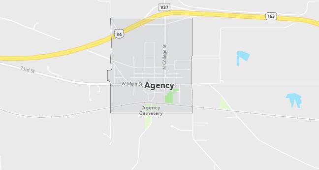
Moving to Agency, Iowa
The current estimated population of Agency, Iowa is 639, with 49.3% male and 50.7% female. Agency has maintained a stable population, reflecting its role as a small, rural community with strong ties to the surrounding agricultural economy.
City Facts
- Year founded: 1843
- County: Wapello
- Land area: 1.1 square miles
- Population density: Approximately 581 people per square mile
- Area code: 641
- Zip code: 52530
Geography and Location
Agency, Iowa is located in southeastern Iowa, in Wapello County, just a few miles east of Ottumwa. The town is situated along U.S. Highway 34, making it easily accessible to larger cities in the region. Agency is known for its quiet, rural character, with agricultural fields and small forests surrounding the town. The area’s history includes its role as a former trading post for Native American tribes and early settlers, and there are several historical landmarks in and around the town. The nearby Des Moines River offers opportunities for fishing, boating, and other outdoor recreational activities. Agency provides a peaceful, small-town environment with access to amenities in nearby Ottumwa.
Demographics
Median resident age: 42.8 years
Median household income: $36,912
Median house value: $62,500
Population by Race
Races in Agency:
- White Non-Hispanic (98.6%)
- Hispanic (0.8%)
Ancestries: German (23.5%), United States (17.0%), Irish (11.7%), English (10.6%), Norwegian (7.2%), Swedish (4.5%).
Land area: 0.6 square miles

Population by Education
For population 25 years and over in Agency
- High school or higher: 88.9%
- Bachelor’s degree or higher: 7.4%
- Graduate or professional degree: 0.9%
- Unemployed: 1.7%
- Mean travel time to work: 20.2 minutes
For population 15 years and over in Agency city
- Never married: 14.0%
- Now married: 63.9%
- Separated: 0.4%
- Widowed: 12.7%
- Divorced: 9.0%
0.6% Foreign born
Population change in the 1990s: -38 (-5.8%).
Hospitals
Hospitals/medical centers near Agency:
- OTTUMWA REGIONAL HEALTH CENTER (about 8 miles; OTTUMWA, IA)
- DAVIS COUNTY HOSPITAL (about 21 miles; BLOOMFIELD, IA)
- KEOKUK COUNTY HEALTH CENTER (about 25 miles; SIGOURNEY, IA)
Airports
Airports certified for carrier operations nearest to Agency:
- OTTUMWA INDUSTRIAL (about 12 miles; OTTUMWA, IA; Abbreviation: OTM)
- KIRKSVILLE REGIONAL (about 65 miles; KIRKSVILLE, MO; Abbreviation: IRK)
- THE EASTERN IOWA (about 75 miles; CEDAR RAPIDS, IA; Abbreviation: CID)
Other public-use airports nearest to Agency:
- OSKALOOSA MUNI (about 20 miles; OSKALOOSA, IA; Abbreviation: OOA)
- BLOOMFIELD MUNI (about 21 miles; BLOOMFIELD, IA; Abbreviation: 4K6)
- FAIRFIELD MUNI (about 24 miles; FAIRFIELD, IA; Abbreviation: FFL)
Amtrak station near Agency:
- 8 miles: OTTUMWA (210 W. MAIN ST.). Services: ticket office, partially wheelchair accessible, enclosed waiting area, public restrooms, public payphones, free short-term parking, free long-term parking, call for car rental service, call for taxi service, intercity bus service.
Colleges and Universities
Colleges/universities with over 2000 students nearest to Agency:
- INDIAN HILLS COMMUNITY COLLEGE (about 8 miles; OTTUMWA, IA; Full-time enrollment: 2,744)
- TRUMAN STATE UNIVERSITY (about 59 miles; KIRKSVILLE, MO; Full-time enrollment: 5,922)
- UNIVERSITY OF IOWA (about 71 miles; IOWA CITY, IA; Full-time enrollment: 24,766)
- KIRKWOOD COMMUNITY COLLEGE (about 97 miles; CEDAR RAPIDS, IA; Full-time enrollment: 7,991)
- UNIVERSITY OF NORTHERN IOWA (about 102 miles; CEDAR FALLS, IA; Full-time enrollment: 12,524)
- HAWKEYE COMMUNITY COLLEGE (about 102 miles; WATERLOO, IA; Full-time enrollment: 3,292)
- DES MOINES COMMUNITY COLLEGE (about 103 miles; ANKENY, IA; Full-time enrollment: 6,959)
Libraries
Library in Agency:
- AGENCY PUBLIC LIBRARY (Operating income: $11,441; Location: 104 E MAIN; 5,765 books; 97 audio materials; 194 video materials; 26 serial subscriptions)
