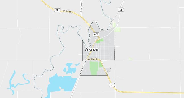
Moving to Akron, Iowa
The current estimated population of Akron is 1,450, with 47% male and 53% female. The population has remained stable, supported by the town’s agricultural economy and its role as a small regional hub.
City Facts
- Year founded: 1882
- County: Plymouth County
- Land area: 1.36 square miles
- Population density: 1,066 people per square mile
- Area code: 712
- Zip code: 51001
Geography and Location
Akron is located in northwestern Iowa, near the Iowa-South Dakota border, in Plymouth County. The town is situated along the Big Sioux River, which provides a natural border between Iowa and South Dakota. Akron lies in a predominantly agricultural region, with vast farmlands and gently rolling hills surrounding the town. The town is located along Iowa Highway 12, providing access to nearby cities like Sioux City. The climate in Akron is typical of the Midwest, with cold winters and warm summers.
Demographics
Median resident age: 41.9 years
Median household income: $29,583
Median house value: $71,300
Population by Race
Races in Akron:
- White Non-Hispanic (98.9%)
Ancestries: German (43.6%), Irish (14.9%), English (10.6%), Norwegian (8.9%), Swedish (6.7%), United States (6.7%).
Elevation: 1147 feet
Land area: 1.2 square miles

Population by Education
For population 25 years and over in Akron
- High school or higher: 81.9%
- Bachelor’s degree or higher: 13.3%
- Graduate or professional degree: 3.2%
- Unemployed: 3.5%
- Mean travel time to work: 21.4 minutes
For population 15 years and over in Akron city
- Never married: 18.4%
- Now married: 60.7%
- Separated: 0.9%
- Widowed: 12.1%
- Divorced: 7.9%
1.2% Foreign born
Population change in the 1990s: +21 (+1.4%).
Hospitals
Hospitals/medical centers near Akron:
- HAWARDEN COMMUNITY HOSPITAL (about 14 miles; HAWARDEN, IA)
- SIOUXLAND SURGERY CENTER LP (about 22 miles; DAKOTA DUNES, SD)
- ST LUKES REGIONAL MEDICAL CENTER (about 24 miles; SIOUX CITY, IA)
Airports
Airports certified for carrier operations nearest to Akron:
- SIOUX GATEWAY/COL. BUD DAY FIELD (about 32 miles; SIOUX CITY, IA; Abbreviation: SUX)
- JOE FOSS FIELD (about 53 miles; SIOUX FALLS, SD; Abbreviation: FSD)
- CHAN GURNEY MUNI (about 58 miles; YANKTON, SD; Abbreviation: YKN)
Other public-use airports nearest to Akron:
- AKRON MUNI (about 1 miles; AKRON, IA; Abbreviation: Y40)
- HAWARDEN MUNI (about 16 miles; HAWARDEN, IA; Abbreviation: 2Y2)
- GRAHAM FIELD (about 21 miles; NORTH SIOUX CITY, SD; Abbreviation: 7K7)
Colleges and Universities
Colleges/universities with over 2000 students nearest to Akron:
- UNIVERSITY OF SOUTH DAKOTA (about 27 miles; VERMILLION, SD; Full-time enrollment: 6,014)
- WESTERN IOWA TECH COMMUNITY COLLEGE (about 36 miles; SIOUX CITY, IA; Full-time enrollment: 2,639)
- WAYNE STATE COLLEGE (about 53 miles; WAYNE, NE; Full-time enrollment: 3,026)
- NORTHEAST COMMUNITY COLLEGE (about 96 miles; NORFOLK, NE; Full-time enrollment: 2,732)
- BUENA VISTA UNIVERSITY (about 96 miles; STORM LAKE, IA; Full-time enrollment: 2,524)
- SOUTH DAKOTA STATE UNIVERSITY (about 108 miles; BROOKINGS, SD; Full-time enrollment: 7,353)
- UNIVERSITY OF NEBRASKA AT OMAHA (about 109 miles; OMAHA, NE; Full-time enrollment: 10,150)
Schools
Public high school in Akron:
- AKRON WESTFIELD SENIOR HIGH SCHOOL (Students: 206; Location: 850 KERR DRIVE; Grades: 09 – 12)
Public primary/middle schools in Akron:
- AKRON WESTFIELD ELEMENTARY SCHOOL (Students: 255; Location: 850 KERR DR; Grades: PK – 05)
- AKRON WESTFIELD MIDDLE SCHOOL (Students: 168; Location: 850 KERR DR; Grades: 06 – 08)
Libraries
Library in Akron:
- AKRON PUBLIC LIBRARY (Operating income: $63,865; Location: 350 REED ST.; 13,421 books; 221 audio materials; 486 video materials; 66 serial subscriptions)
