Moving to Alakanuk, Alaska
The current estimated population of Alakanuk, Alaska is 684, with 52% male and 48% female. The population of Alakanuk has remained relatively stable, reflecting its status as a small, remote community with strong ties to subsistence fishing and local traditions.
City Facts
- Year founded: 1969 (incorporated)
- County: Kusilvak Census Area
- Land area: 38.8 square miles
- Population density: Approximately 17.6 people per square mile
- Area code: 907
- Zip code: 99554
Geography and Location
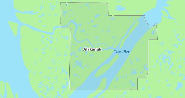
Alakanuk, Alaska is located in the southwestern part of the state, near the mouth of the Yukon River, where it empties into the Bering Sea. The town is part of the Kusilvak Census Area and is accessible primarily by air or river, reflecting its remote location. The community is largely made up of Alaska Native peoples, with subsistence fishing and hunting playing a vital role in daily life. The surrounding landscape is characterized by flat, low-lying tundra, rivers, and wetlands. The region’s harsh winters and short summers define the lifestyle, with strong community ties and traditional practices central to the culture.
Demographics
Median resident age: 20.4 years
Median household income: $26,346
Median house value: $42,500
Population by Race
Races in Alakanuk:
- American Indian (97.9%)
- Two or more races (2.5%)
- White Non-Hispanic (2.0%)
Ancestries: Swedish (2.0%), German (1.8%), Irish (1.7%).
Land area: 32.4 square miles

Population by Education
For population 25 years and over in Alakanuk
- High school or higher: 51.2%
- Bachelor’s degree or higher: 6.5%
- Graduate or professional degree: 2.1%
- Unemployed: 21.5%
- Mean travel time to work: 5.9 minutes
For population 15 years and over in Alakanuk city
- Never married: 39.9%
- Now married: 49.5%
- Separated: 1.2%
- Widowed: 7.2%
- Divorced: 2.2%
0.0% Foreign born
Population change in the 1990s: +102 (+18.5%).
Hospitals
Hospitals/medical centers near Alakanuk:
- NORTON SOUND REGIONAL HOSPITAL (about 131 miles; NOME, AK)
- YUKON KUSKOKWIM DELTA REG HOSPITAL (about 233 miles; BETHEL, AK)
- MANILAQ HEALTH CENTER (about 323 miles; KOTZEBUE, AK)
Airports
Airports certified for carrier operations nearest to Alakanuk:
- NOME (about 137 miles; NOME, AK; Abbreviation: OME)
- BETHEL (about 235 miles; BETHEL, AK; Abbreviation: BET)
- RALPH WIEN MEMORIAL (about 322 miles; KOTZEBUE, AK; Abbreviation: OTZ)
Other public-use airports nearest to Alakanuk:
- ALAKANUK (about 2 miles; ALAKANUK, AK; Abbreviation: AUK)
- EMMONAK (about 14 miles; EMMONAK, AK; Abbreviation: ENM)
- SHELDON POINT (about 18 miles; SHELDON POINT, AK; Abbreviation: SXP)
Colleges and Universities
Colleges/universities with over 2000 students nearest to Alakanuk:
- UNIVERSITY OF ALASKA ANCHORAGE (about 1031 miles; ANCHORAGE, AK; Full-time enrollment: 9,453)
- UNIVERSITY OF ALASKA FAIRBANKS (about 1173 miles; FAIRBANKS, AK; Full-time enrollment: 5,034)
- BRIGHAM YOUNG UNIVERSITY-HAWAII CAMPUS (about 2858 miles; LAIE, HI; Full-time enrollment: 2,273)
- LEEWARD COMMUNITY COLLEGE (about 2874 miles; PEARL CITY, HI; Full-time enrollment: 3,511)
- HONOLULU COMMUNITY COLLEGE (about 2880 miles; HONOLULU, HI; Full-time enrollment: 2,787)
- HAWAII PACIFIC UNIVERSITY (about 2882 miles; HONOLULU, HI; Full-time enrollment: 6,186)
- UNIVERSITY OF HAWAII AT MANOA (about 2882 miles; HONOLULU, HI; Full-time enrollment: 14,113)
Public primary/middle school in Alakanuk:
- ALAKANUK SCHOOL (Students: 225; Location: PO BOX 9; Grades: PK – 12)
