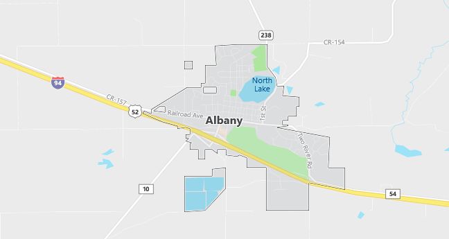
Moving to Albany, Minnesota
The current estimated population of Albany, Minnesota is 2,780, with 50.1% male and 49.9% female. Albany has seen steady population growth, benefiting from its location along Interstate 94 and its role as a local center for commerce and agriculture in central Minnesota.
City Facts
- Year founded: 1890
- County: Stearns
- Land area: 2.2 square miles
- Population density: Approximately 1,264 people per square mile
- Area code: 320
- Zip code: 56307
Geography and Location
Albany, Minnesota is located in Stearns County, in central Minnesota, about 20 miles west of St. Cloud. The town is situated along Interstate 94, making it a convenient stop for travelers and a strategic location for businesses. Albany is surrounded by farmland, with agriculture playing a key role in the local economy. The town’s rural landscape is characterized by rolling fields, forests, and lakes, typical of the central Minnesota region. Albany offers a peaceful, small-town environment with access to outdoor activities such as fishing, hiking, and snowmobiling. The town’s proximity to St. Cloud also provides residents with access to larger city amenities and services.
Demographics
Median resident age: 35.8 years
Median household income: $31,577
Median house value: $88,800
Population by Race
Races in Albany:
- White Non-Hispanic (98.7%)
- Two or more races (0.8%)
- American Indian (0.7%)
Ancestries: German (63.4%), Irish (8.2%), Norwegian (6.7%), Polish (6.6%), United States (5.1%), Swedish (3.1%).
Elevation: 1200 feet
Land area: 1.4 square miles

Population by Education
For population 25 years and over in Albany
- High school or higher: 72.0%
- Bachelor’s degree or higher: 15.9%
- Graduate or professional degree: 5.5%
- Unemployed: 4.3%
- Mean travel time to work: 18.9 minutes
For population 15 years and over in Albany city
- Never married: 21.1%
- Now married: 56.0%
- Separated: 1.0%
- Widowed: 12.3%
- Divorced: 9.6%
0.6% Foreign born
Population change in the 1990s: +220 (+14.0%).
Hospitals
Hospital/medical center in Albany:
- ALBANY AREA HOSPITAL (300 THIRD AVENUE)
Other hospitals/medical centers near Albany:
- MELROSE AREA HOSPITAL CENTRACARE (about 17 miles; MELROSE, MN)
- PAYNESVILLE AREA HOSPITAL (about 20 miles; PAYNESVILLE, MN)
- ST CLOUD HOSPITAL (about 27 miles; SAINT CLOUD, MN)
Airports
Airports certified for carrier operations nearest to Albany:
- ST CLOUD REGIONAL (about 37 miles; ST CLOUD, MN; Abbreviation: STC)
- BRAINERD LAKES RGNL (about 60 miles; BRAINERD, MN; Abbreviation: BRD)
- MINNEAPOLIS-ST PAUL INTL/WOLD-CHAMBERLAIN/ (about 108 miles; MINNEAPOLIS, MN; Abbreviation: MSP)
Other public-use airports nearest to Albany:
- SAUK CENTRE MUNI (about 26 miles; SAUK CENTRE, MN; Abbreviation: D39)
- LITTLE FALLS/MORRISON COUNTY-LINDBERGH FLD (about 27 miles; LITTLE FALLS, MN; Abbreviation: LXL)
- TODD FIELD (about 27 miles; LONG PRAIRIE, MN; Abbreviation: 14Y)
Colleges and Universities
Colleges/universities with over 2000 students nearest to Albany:
- SAINT CLOUD STATE UNIVERSITY (about 27 miles; ST CLOUD, MN; Full-time enrollment: 12,913)
- SAINT CLOUD TECHNICAL COLLEGE (about 27 miles; ST CLOUD, MN; Full-time enrollment: 2,183)
- RIDGEWATER COLLEGE (about 49 miles; WILLMAR, MN; Full-time enrollment: 2,711)
- CENTRAL LAKES COLLEGE-BRAINERD (about 57 miles; BRAINERD, MN; Full-time enrollment: 2,364)
- HENNEPIN TECHNICAL COLLEGE (about 90 miles; BROOKLYN PARK, MN; Full-time enrollment: 3,138)
- NORTH HENNEPIN COMMUNITY COLLEGE (about 90 miles; BROOKLYN PARK, MN; Full-time enrollment: 3,097)
- ANOKA-RAMSEY COMMUNITY COLLEGE (about 93 miles; COON RAPIDS, MN; Full-time enrollment: 3,627)
Schools
Public high school in Albany:
- ALBANY SR. (Students: 522; Location: 30 FOREST AVE.; Grades: 09 – 12)
Public primary/middle schools in Albany:
- ALBANY EL. (Students: 443; Location: 10 FOREST AVE.; Grades: PK – 06)
- ALBANY JR. (Students: 263; Location: 30 FOREST AVE.; Grades: 07 – 08)
Private primary/middle school in Albany:
- HOLY FAMILY SCHOOL (Students: 128; Location: BOX 674; Grades: KG – 6)
