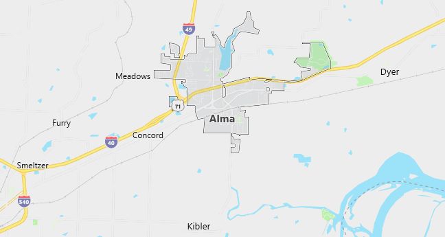
Moving to Alma, Arkansas
The current estimated population of Alma is 5,700, with 48% male and 52% female. The population has seen moderate growth due to its location along major transportation routes.
City Facts
- Year founded: 1872
- County: Crawford County
- Land area: 5.7 square miles
- Population density: 1,000 people per square mile
- Area code: 479
- Zip code: 72921
Geography and Location
Alma is located in northwestern Arkansas, in Crawford County, near the Arkansas River. The town is situated along Interstate 40 and U.S. Route 71, making it a key transportation hub in the region. Alma is known as the “Spinach Capital of the World” due to its large spinach production. The surrounding landscape includes rolling hills, forests, and farmlands. The town experiences a humid subtropical climate, with hot summers and mild winters.
Demographics
Median resident age: 31.1 years
Median household income: $28,906
Median house value: $75,600
Population by Race
Races in Alma:
- White Non-Hispanic (91.9%)
- Hispanic (3.7%)
- American Indian (2.1%)
- Black (1.7%)
- Two or more races (1.1%)
- Other race (0.7%)
Ancestries: United States (22.8%), Irish (7.7%), English (6.8%), German (3.9%), Dutch (1.3%), Scottish (1.3%).
Elevation: 432 feet
Land area: 4.8 square miles

Population by Education
For population 25 years and over in Alma
- High school or higher: 75.7%
- Bachelor’s degree or higher: 12.9%
- Graduate or professional degree: 2.7%
- Unemployed: 7.9%
- Mean travel time to work: 21.5 minutes
For population 15 years and over in Alma city
- Never married: 14.7%
- Now married: 63.3%
- Separated: 0.6%
- Widowed: 6.8%
- Divorced: 14.7%
0.9% Foreign born
Population change in the 1990s: +835 (+25.1%).
Hospitals
Hospitals/medical centers near Alma:
- CRAWFORD COUNTY MEMORIAL HOSPITAL (about 9 miles; VAN BUREN, AR)
- HEALTHSOUTH REHAB HOSP OF FORT SMITH (about 16 miles; FORT SMITH, AR)
- SPARKS REGIONAL MEDICAL CENTER (about 16 miles; FORT SMITH, AR)
Airports
Airports certified for carrier operations nearest to Alma:
- FORT SMITH REGIONAL (about 15 miles; FORT SMITH, AR; Abbreviation: FSM)
- DRAKE FIELD (about 36 miles; FAYETTEVILLE, AR; Abbreviation: FYV)
- NORTHWEST ARKANSAS RGNL (about 54 miles; FAYETTEVILLE/SPRINGDALE/, AR; Abbreviation: XNA)
Other public-use airports nearest to Alma:
- OZARK-FRANKLIN COUNTY (about 27 miles; OZARK, AR; Abbreviation: 7M5)
- STILWELL/CHEROKEE NATION (about 34 miles; STILWELL, OK; Abbreviation: O11)
- BOONEVILLE MUNI (about 36 miles; BOONEVILLE, AR; Abbreviation: 4M2)
Colleges and Universities
Colleges/universities with over 2000 students nearest to Alma:
- WESTARK COLLEGE (about 21 miles; FT SMITH, AR; Full-time enrollment: 3,472)
- UNIVERSITY OF ARKANSAS MAIN CAMPUS (about 39 miles; FAYETTEVILLE, AR; Full-time enrollment: 13,324)
- NORTHEASTERN STATE UNIVERSITY (about 60 miles; TAHLEQUAH, OK; Full-time enrollment: 6,610)
- NORTHWEST ARKANSAS COMMUNITY COLLEGE (about 61 miles; BENTONVILLE, AR; Full-time enrollment: 2,197)
- ARKANSAS TECH UNIVERSITY (about 77 miles; RUSSELLVILLE, AR; Full-time enrollment: 4,450)
- MISSOURI SOUTHERN STATE COLLEGE (about 113 miles; JOPLIN, MO; Full-time enrollment: 4,569)
- HENDERSON STATE UNIVERSITY (about 122 miles; ARKADELPHIA, AR; Full-time enrollment: 3,109)
Schools
Public high school in Alma:
- ALMA HIGH SCHOOL (Students: 908; Location: 101 EAST MAIN; Grades: 09 – 12)
Public primary/middle schools in Alma:
- ALMA MIDDLE SCHOOL (Students: 726; Location: 706 HWY 64 E.; Grades: 06 – 08)
- ALMA PRIMARY SCHOOL (Students: 708; Location: 1600 HWY 64 E.; Grades: KG – 02)
- ALMA INTERMEDIATE SCHOOL (Students: 693; Location: 1220 WEST COLLUM LANE; Grades: 03 – 05)
