Moving to Alma, Georgia
The current estimated population of Alma is 3,500, with 48% male and 52% female. The population has remained stable, supported by agriculture, particularly in blueberry production.
City Facts
- Year founded: 1904
- County: Bacon County
- Land area: 6.0 square miles
- Population density: 583 people per square mile
- Area code: 912
- Zip code: 31510
Geography and Location
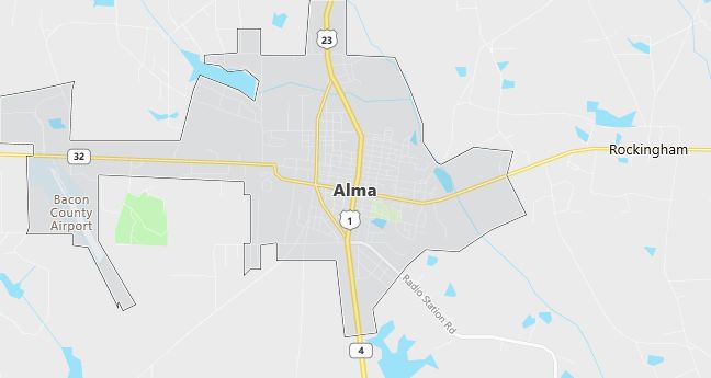
Alma is located in southeastern Georgia, in Bacon County, where it serves as the county seat. The town is known for its large blueberry farms and agricultural base. Alma is situated along U.S. Route 1, providing access to nearby cities like Waycross and Douglas. The surrounding landscape is characterized by flat farmland and pine forests. Alma experiences a humid subtropical climate, with hot, humid summers and mild winters.
Demographics
Median resident age: 36.0 years
Median household income: $20,324
Median house value: $55,200
Population by Race
Races in Alma:
- White Non-Hispanic (56.1%)
- Black (38.6%)
- Hispanic (4.4%)
- Other race (1.9%)
- Two or more races (1.0%)
Ancestries: United States (22.2%), Irish (5.1%), English (4.7%).
Elevation: 201 feet
Land area: 5.7 square miles

Population by Education
For population 25 years and over in Alma
- High school or higher: 60.7%
- Bachelor’s degree or higher: 6.2%
- Graduate or professional degree: 2.5%
- Unemployed: 4.9%
- Mean travel time to work: 17.9 minutes
For population 15 years and over in Alma city
- Never married: 28.2%
- Now married: 44.6%
- Separated: 1.9%
- Widowed: 9.7%
- Divorced: 15.6%
0.6% Foreign born
Population change in the 1990s: -476 (-12.8%).
Hospitals
Hospitals/medical centers in Alma:
- BACON COUNTY HOSPITAL (302 S WAYNE ST BOX 745)
- BACON COUNTY HOSPITAL (302 SOUTH WAYNE STREET)
Other hospitals/medical centers near Alma:
- APPLING HOSPITAL (about 18 miles; BAXLEY, GA)
- JEFF DAVIS HOSPITAL (about 23 miles; HAZLEHURST, GA)
- SATILLA REGIONAL MEDICAL CENTER (about 24 miles; WAYCROSS, GA)
Airports
Airports certified for carrier operations nearest to Alma:
- MOODY AFB (about 64 miles; VALDOSTA, GA; Abbreviation: VAD)
- BRUNSWICK GOLDEN ISLES (about 74 miles; BRUNSWICK, GA; Abbreviation: BQK)
- VALDOSTA RGNL (about 77 miles; VALDOSTA, GA; Abbreviation: VLD)
Other public-use airports nearest to Alma:
- BACON COUNTY (about 3 miles; ALMA, GA; Abbreviation: AMG)
- BAXLEY MUNI (about 13 miles; BAXLEY, GA; Abbreviation: BHC)
- WAYCROSS-WARE COUNTY (about 22 miles; WAYCROSS, GA; Abbreviation: AYS)
Colleges and Universities
Colleges/universities with over 2000 students nearest to Alma:
- VALDOSTA STATE UNIVERSITY (about 75 miles; VALDOSTA, GA; Full-time enrollment: 7,157)
- GEORGIA SOUTHERN UNIVERSITY (about 77 miles; STATESBORO, GA; Full-time enrollment: 12,724)
- ARMSTRONG ATLANTIC STATE UNIVERSITY (about 93 miles; SAVANNAH, GA; Full-time enrollment: 3,945)
- FLORIDA COMMUNITY COLLEGE AT JACKSONVILLE (about 101 miles; JACKSONVILLE, FL; Full-time enrollment: 10,495)
- SAVANNAH COLLEGE OF ART AND DESIGN (about 101 miles; SAVANNAH, GA; Full-time enrollment: 4,565)
- UNIVERSITY OF NORTH FLORIDA (about 111 miles; JACKSONVILLE, FL; Full-time enrollment: 9,256)
- ALBANY STATE UNIVERSITY (about 113 miles; ALBANY, GA; Full-time enrollment: 2,996)
Schools
Public high school in Alma:
- BACON COUNTY HIGH SCHOOL (Students: 517; Location: 901 NORTH PIERCE STREET; Grades: 09 – 12)
Public primary/middle schools in Alma:
- BACON COUNTY PRIMARY SCHOOL (Students: 534; Location: 251 CUMBERLAND ROAD; Grades: PK – 02)
- BACON COUNTY MIDDLE SCHOOL (Students: 428; Location: 901 NORTH PIERCE STREET; Grades: 06 – 08)
- BACON COUNTY ELEMENTARY SCHOOL (Students: 405; Location: 523 EAST 16TH STREET; Grades: 03 – 05)
