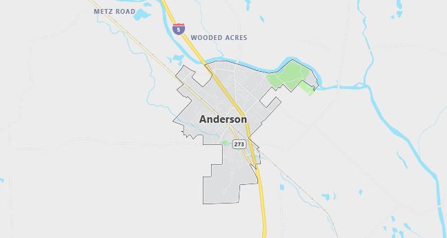
Moving to Anderson, California
The current estimated population of Anderson, California, is 10,322, with approximately 49% male and 51% female. The city has seen steady population growth, primarily driven by its proximity to Redding and affordable housing options.
City Facts
- Year Founded: 1872
- County Affiliated: Shasta County
- Land Area: 6.57 square miles
- Population Density: 1,571 people per square mile
- Area Code: 530
- Zip Codes: 96007
Geography and Location
Anderson, California, is located in Shasta County in the northern part of the state, approximately 10 miles south of Redding. It lies in the Sacramento Valley, part of California’s vast Central Valley region, and is bordered by the Sacramento River to the west. Anderson enjoys a Mediterranean climate, with hot, dry summers and mild, wet winters. The city’s proximity to both mountains and waterways provides access to numerous outdoor recreational activities, such as fishing in the Sacramento River, hiking in nearby national forests, and exploring Shasta Lake and Lassen Volcanic National Park. The geography surrounding Anderson is primarily flat and agricultural, with farmlands extending into the valley, but the Sierra Nevada and Cascade Mountain ranges are visible in the distance, offering stunning views and a more varied terrain just a short drive away.
Demographics
Median resident age: 32.2 years
Median household income: $24,558
Median house value: $86,900
Population by Race
Races in Anderson:
- White Non-Hispanic (83.4%)
- Hispanic (7.3%)
- American Indian (6.8%)
- Two or more races (4.5%)
- Other race (2.3%)
- Other Asian (1.4%)
- Black (0.6%)
(Total can be greater than 100% because Hispanics could be counted in other races)
Ancestries: Irish (14.7%), German (13.8%), English (11.5%), United States (9.6%), Italian (4.8%), French (4.3%).
Elevation: 430 feet
Land area: 6.4 square miles

Population by Education
For population 25 years and over in Anderson
- High school or higher: 76.0%
- Bachelor’s degree or higher: 7.0%
- Graduate or professional degree: 1.7%
- Unemployed: 10.5%
- Mean travel time to work: 20.2 minutes
For population 15 years and over in Anderson city
- Never married: 24.7%
- Now married: 50.1%
- Separated: 1.9%
- Widowed: 6.8%
- Divorced: 16.5%
4.7% Foreign born (2.1% Latin America, 1.3% Asia, 0.9% Europe).
Population change in the 1990s: +561 (+6.6%).
Hospitals
Hospitals/medical centers near Anderson:
- MERCY MEDICAL CENTER REDDING (about 12 miles; REDDING, CA)
- NORTHERN CALIFORNIA REHAB HOSPITAL (about 12 miles; REDDING, CA)
- PATIENTS’ HOSPITAL OF REDDING (about 12 miles; REDDING, CA)
Airports
Airports certified for carrier operations nearest to Anderson:
- REDDING MUNI (about 4 miles; REDDING, CA; Abbreviation: RDD)
- CHICO MUNI (about 56 miles; CHICO, CA; Abbreviation: CIC)
- BEALE AFB (about 109 miles; MARYSVILLE, CA; Abbreviation: BAB)
Other public-use airports nearest to Anderson:
- BENTON FIELD (about 11 miles; REDDING, CA; Abbreviation: O85)
- BRIDGE BAY RESORT (about 21 miles; REDDING, CA; Abbreviation: Q83)
- RED BLUFF MUNI (about 22 miles; RED BLUFF, CA; Abbreviation: RBL)
Amtrak stations near Anderson:
- 12 miles: REDDING (1620 YUBA ST.). Services: fully wheelchair accessible, public payphones, free short-term parking, call for taxi service.
- 20 miles: RED BLUFF (460 ANTELOPE BLVD.) – Bus Station. Services: fully wheelchair accessible, public payphones, free short-term parking, call for taxi service.
Colleges and Universities
Colleges/universities with over 2000 students nearest to Anderson:
- SHASTA COLLEGE (about 18 miles; REDDING, CA; Full-time enrollment: 5,251)
- CALIFORNIA STATE UNIVERSITY-CHICO (about 61 miles; CHICO, CA; Full-time enrollment: 14,658)
- BUTTE COLLEGE (about 79 miles; Oroville, CA; Full-time enrollment: 7,061)
- YUBA COLLEGE (about 104 miles; MARYSVILLE, CA; Full-time enrollment: 5,593)
- MENDOCINO COLLEGE (about 109 miles; UKIAH, CA; Full-time enrollment: 2,080)
- SOUTHERN OREGON UNIVERSITY (about 121 miles; ASHLAND, OR; Full-time enrollment: 4,424)
- HUMBOLDT STATE UNIVERSITY (about 127 miles; ARCATA, CA; Full-time enrollment: 6,800)
Schools
Public high schools in Anderson:
- ANDERSON HIGH (Students: 873; Location: 1471 FERRY ST.; Grades: 09 – 12)
- OAKVIEW HIGH (ALTER.) (Students: 141; Location: 2684 GATEWAY DR.; Grades: 09 – 12)
- ANDERSON NEW TECHNOLOGY HIGH SCHOOL (Students: 118; Location: 1469 FERRY STREET; Grades: 09 – 12)
- NORTH VALLEY HIGH (CONT.) (Students: 112; Location: 20083 OLINDA ROAD; Grades: 09 – 12)
- ANDERSON COMMUNITY DAY (Students: 18; Location: 5250 W. ANDERSON DR.; Grades: 09 – 12)
Public primary/middle schools in Anderson:
- ANDERSON MIDDLE (Students: 547; Location: 1646 W. FERRY; Grades: 06 – 08)
- MEADOW LANE ELEMENTARY (Students: 450; Location: 2770 BALLS FERRY ROAD; Grades: KG – 05)
- HAPPY VALLEY ELEMENTARY (Students: 372; Location: 17480 PALM AVE.; Grades: 03 – 08)
- ANDERSON HEIGHTS ELEMENTARY (Students: 287; Location: 1530 SPRUCE ST.; Grades: KG – 05)
- PRAIRIE ELEMENTARY (Students: 281; Location: 20981 DEESCH ROAD; Grades: KG – 03)
- VERDE VALE ELEMENTARY (Students: 258; Location: 19415 JACQUELINE ST.; Grades: KG – 05)
- HAPPY VALLEY PRIMARY (Students: 245; Location: 16300 CLOVERDALE ROAD; Grades: KG – 04)
- CASCADE COMMUNITY DAY (Students: 12; Location: 1697 WEST MILL STREET; Grades: KG – 06)
- HAPPY VALLEY COMMUNITY DAY (ELEM) (Students: 10; Location: 1697 WEST MILL STREET; Grades: 06 – 08)
- PACHECO COMMUNITY DAY (Students: 10; Location: 1697 WEST MILL STREET; Grades: 06 – 08)
Private primary/middle school in Anderson:
- SACRED HEART ELEMENTARY SCHOOL (Students: 130; Location: 3167 SAINT STEPHANS DR; Grades: PK – 5)
