Moving to Ansonia, Connecticut
The current estimated population of Ansonia, Connecticut, is 18,724, with approximately 48% male and 52% female. The population has remained relatively stable, with slight growth due to its suburban location within the New York metropolitan area.
City Facts
- Year Founded: 1844
- County Affiliated: New Haven County
- Land Area: 6.1 square miles
- Population Density: 3,070 people per square mile
- Area Code: 203
- Zip Codes: 06401
Geography and Location
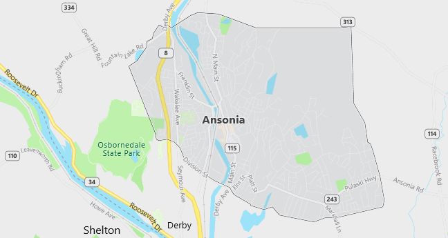
Ansonia, Connecticut, is a small city located in southwestern Connecticut, within New Haven County. It is situated along the Naugatuck River, about 12 miles northwest of New Haven and 70 miles from New York City, making it part of the Greater New York metropolitan area. Ansonia experiences a humid continental climate, with cold winters and warm summers. The city’s geography is defined by its location in the Naugatuck River Valley, which provides scenic river views and contributes to the region’s industrial history. Ansonia has a mix of residential neighborhoods and historic industrial buildings, many of which have been repurposed for modern use. The town’s proximity to major highways, including Route 8 and Interstate 95, offers easy access to nearby cities such as Bridgeport and New Haven. Ansonia’s location near the Long Island Sound also provides access to coastal recreational areas. Known for its rich manufacturing history, particularly in the production of copper, brass, and textiles, Ansonia has maintained a mix of industrial and residential character, with ongoing efforts to revitalize its downtown area.
Demographics
Median resident age: 36.8 years
Median household income: $43,026
Median house value: $140,000
Population by Race
Races in Ansonia:
- White Non-Hispanic (81.2%)
- Black (8.4%)
- Hispanic (7.4%)
- Two or more races (2.4%)
- Other race (2.2%)
- American Indian (0.8%)
- Asian Indian (0.6%)
(Total can be greater than 100% because Hispanics could be counted in other races)
Ancestries: Italian (29.0%), Irish (17.5%), Polish (12.2%), German (9.3%), English (6.9%), French (5.2%).
Elevation: 141 feet
Land area: 6.0 square miles

Population by Education
For population 25 years and over in Ansonia
- High school or higher: 82.2%
- Bachelor’s degree or higher: 15.0%
- Graduate or professional degree: 5.7%
- Unemployed: 5.0%
- Mean travel time to work: 22.7 minutes
For population 15 years and over in Ansonia city
- Never married: 28.6%
- Now married: 52.5%
- Separated: 1.4%
- Widowed: 7.5%
- Divorced: 10.1%
11.1% Foreign born (7.1% Europe, 2.6% Latin America).
Population change in the 1990s: +114 (+0.6%).
Hospitals
Hospitals/medical centers near Ansonia:
- GRIFFIN HOSPITAL (about 2 miles; DERBY, CT)
- MILFORD HOSPITAL, INC (about 9 miles; MILFORD, CT)
- YALE-NEW HAVEN HOSPITAL (about 10 miles; NEW HAVEN, CT)
Airports
Airports certified for carrier operations nearest to Ansonia:
- IGOR I SIKORSKY MEMORIAL (about 14 miles; BRIDGEPORT, CT; Abbreviation: BDR)
- TWEED-NEW HAVEN (about 15 miles; NEW HAVEN, CT; Abbreviation: HVN)
- DANBURY MUNI (about 28 miles; DANBURY, CT; Abbreviation: DXR)
Other public-use airports nearest to Ansonia:
- WATERBURY-OXFORD (about 10 miles; OXFORD, CT; Abbreviation: OXC)
- WATERBURY (about 21 miles; WATERBURY, CT; Abbreviation: N41)
- MERIDEN MARKHAM MUNI (about 21 miles; MERIDEN, CT; Abbreviation: MMK)
Amtrak stations near Ansonia:
- 11 miles: NEW HAVEN (50 UNION AVE.). Services: ticket office, partially wheelchair accessible, enclosed waiting area, public restrooms, public payphones, snack bar, ATM, paid short-term parking, paid long-term parking, car rental agency, taxi stand, intercity bus service, public transit connection.
- 14 miles: BRIDGEPORT (525 WATER ST.). Services: fully wheelchair accessible, enclosed waiting area, public restrooms, public payphones, snack bar, paid short-term parking, paid long-term parking, call for car rental service, taxi stand, intercity bus service, public transit connection.
- 19 miles: WALLINGFORD (37 HALL AVE.). Services: partially wheelchair accessible, enclosed waiting area, public payphones, free short-term parking, call for car rental service, call for taxi service.
Colleges and Universities
College/University in Ansonia:
- EMMETT O’BRIEN REGIONAL VOCATIONAL TECHNICAL SCH (Location: 141 PRINDLE AVE; Public)
Colleges and Universities
Colleges/universities with over 2000 students nearest to Ansonia:
- SOUTHERN CONNECTICUT STATE UNIVERSITY (about 8 miles; NEW HAVEN, CT; Full-time enrollment: 8,808)
- UNIVERSITY OF NEW HAVEN (about 9 miles; WEST HAVEN, CT; Full-time enrollment: 3,081)
- GATEWAY COMMUNITY COLLEGE (about 11 miles; NEW HAVEN, CT; Full-time enrollment: 2,100)
- YALE UNIVERSITY (about 11 miles; NEW HAVEN, CT; Full-time enrollment: 11,011)
- QUINNIPIAC UNIVERSITY (about 13 miles; HAMDEN, CT; Full-time enrollment: 5,836)
- NAUGATUCK VALLEY COMMUNITY COLLEGE (about 15 miles; WATERBURY, CT; Full-time enrollment: 2,834)
- SACRED HEART UNIVERSITY (about 16 miles; FAIRFIELD, CT; Full-time enrollment: 4,120)
Schools
Public high schools in Ansonia:
- ANSONIA HIGH SCHOOL (Students: 668; Location: 20 PULASKI HWY.; Grades: 09 – 12)
- EMMETT O’BRIEN V-T SCHOOL (Students: 551; Location: 141 PRINDLE AVE.; Grades: 09 – 12)
Public primary/middle schools in Ansonia:
- ANSONIA MIDDLE SCHOOL (Students: 688; Location: 115 HOWARD AVE.; Grades: 06 – 08)
- MEAD SCHOOL (Students: 657; Location: 75 FORD ST.; Grades: 03 – 05)
- PRENDERGAST (Students: 639; Location: 59 FINNEY ST.; Grades: PK – 02)
- HOMEBOUND (Location: 42 GROVE STREET; Grades: PK – 12)
Private primary/middle schools in Ansonia:
- ASSUMPTION SCHOOL (Students: 259; Location: 51 NORTH CLIFF ST; Grades: PK – 8)
- ST JOSEPH SCHOOL (Students: 121; Location: 36 JEWETT STREET; Grades: PK – 8)
- JULIA DAY NURSERY & KINDERGART (Students: 50; Location: 76 CENTRAL STREET; Grades: PK – KG)
Libraries
Library in Ansonia:
- ANSONIA PUBLIC LIBRARY (Operating income: $563,770; Location: 53 SOUTH CLIFF ST.; 76,480 books; 1,350 audio materials; 1,295 video materials; 144 serial subscriptions)
