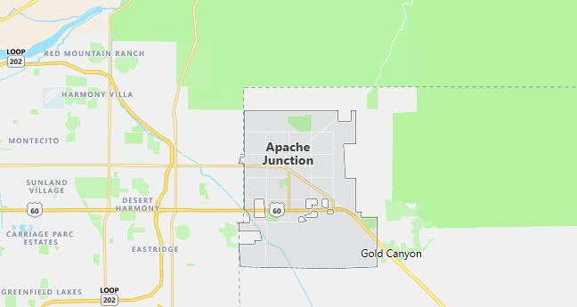
Moving to Apache Junction, Arizona
The current estimated population of Apache Junction is 42,000, with 49% male and 51% female. The population has grown steadily in recent years, driven by its appeal as a retirement community and its proximity to the Phoenix metropolitan area.
City Facts
- Year founded: 1922
- County: Pinal County and Maricopa County
- Land area: 36.5 square miles
- Population density: 1,151 people per square mile
- Area code: 480
- Zip code: 85119, 85120
Geography and Location
Apache Junction is located in the eastern part of the Phoenix metropolitan area, situated at the foot of the Superstition Mountains in central Arizona. The city straddles both Pinal and Maricopa Counties and is about 35 miles east of downtown Phoenix. The town is named after the junction of the Apache Trail and U.S. Route 60, two significant routes in the region’s history. Apache Junction is known for its desert landscape, featuring cacti, rocky terrain, and scenic vistas of the Superstition Mountains, a popular area for hiking, camping, and other outdoor activities. The town experiences a hot desert climate, with extremely hot summers and mild winters, making it a popular destination for retirees and snowbirds seeking a warm climate. The economy is based on tourism, retail, and services catering to the growing residential population. U.S. Route 60 and State Route 88 provide easy access to the Phoenix metropolitan area and nearby recreational sites like the Lost Dutchman State Park and the Tonto National Forest.
Demographics
Median resident age: 44.1 years
Median household income: $33,170
Median house value: $98,400
Population by Race
Races in Apache Junction:
- White Non-Hispanic (87.9%)
- Hispanic (8.8%)
- Other race (3.1%)
- Two or more races (2.0%)
- American Indian (1.8%)
- Black (0.6%)
(Total can be greater than 100% because Hispanics could be counted in other races)
Ancestries: German (19.9%), Irish (13.7%), English (11.1%), United States (6.7%), Italian (4.2%), French (4.1%).
Elevation: 1722 feet
Land area: 34.2 square miles

Population by Education
For population 25 years and over in Apache Junction
- High school or higher: 77.9%
- Bachelor’s degree or higher: 9.0%
- Graduate or professional degree: 2.8%
- Unemployed: 6.5%
- Mean travel time to work: 31.9 minutes
For population 15 years and over in Apache Junction city
- Never married: 15.8%
- Now married: 58.8%
- Separated: 1.9%
- Widowed: 8.8%
- Divorced: 14.8%
4.5% Foreign born (2.3% Latin America, 0.9% North America, 0.6% Europe, 0.5% Asia).
Population change in the 1990s: +13,425 (+73.0%).
Hospitals
Hospitals/medical centers near Apache Junction:
- LUTHERAN HEART HOSPITAL (about 13 miles; MESA, AZ)
- VALLEY LUTHERAN HOSPITAL (about 13 miles; MESA, AZ)
- MESA GENERAL HOSPITAL MEDICAL CENTER (about 21 miles; MESA, AZ)
Airports
Airports certified for carrier operations nearest to Apache Junction:
- WILLIAMS GATEWAY (about 11 miles; PHOENIX, AZ; Abbreviation: IWA)
- PHOENIX SKY HARBOR INTL (about 32 miles; PHOENIX, AZ; Abbreviation: PHX)
- LUKE AFB (about 58 miles; GLENDALE, AZ; Abbreviation: LUF)
Other public-use airports nearest to Apache Junction:
- LOST DUTCHMAN (about 2 miles; APACHE JUNCTION, AZ; Abbreviation: H31)
- FALCON FLD (about 12 miles; MESA, AZ; Abbreviation: FFZ)
- CHANDLER MUNI (about 21 miles; CHANDLER, AZ; Abbreviation: CHD)
Colleges and Universities
Colleges/universities with over 2000 students nearest to Apache Junction:
- CHANDLER/GILBERT COMMUNITY COLLEGE (about 21 miles; CHANDLER, AZ; Full-time enrollment: 2,990)
- SCOTTSDALE COMMUNITY COLLEGE (about 21 miles; SCOTTSDALE, AZ; Full-time enrollment: 5,345)
- MESA COMMUNITY COLLEGE (about 23 miles; MESA, AZ; Full-time enrollment: 11,928)
- RIO SALADO COMMUNITY COLLEGE (about 27 miles; TEMPE, AZ; Full-time enrollment: 4,472)
- AL COLLINS GRAPHIC DESIGN SCHOOL LTD (about 27 miles; TEMPE, AZ; Full-time enrollment: 4,057)
- ARIZONA STATE UNIVERSITY-MAIN CAMPUS (about 27 miles; TEMPE, AZ; Full-time enrollment: 37,174)
- CENTRAL ARIZONA COLLEGE (about 31 miles; COOLIDGE, AZ; Full-time enrollment: 2,333)
Schools
Public high schools in Apache Junction:
- APACHE JUNCTION HIGH SCHOOL (Students: 1,466; Location: 2525 S IRONWOOD RD; Grades: 09 – 12)
- APACHE TRAIL HIGH SCHOOL (Students: 154; Location: 945 WEST APACHE TRAIL; Grades: 09 – 12)
Biggest public primary/middle schools in Apache Junction:
- THUNDER MOUNTAIN MIDDLE SCHOOL (Students: 822; Location: 3700 E. 16TH AVENUE; Grades: 06 – 08)
- DESERT VISTA ELEMENTARY SCHOOL (Students: 730; Location: 3701 E BROADWAY; Grades: KG – 05)
- SUPERSTITION MOUNTAIN ELEMENTARY SCHOOL (Students: 699; Location: 550 S. IRONWOOD; Grades: PK – 05)
- EVIT-APACHE JUNCTION (Students: 640; Location: PO BOX 879; Grades: UG – UG)
- DESERT SHADOWS MIDDLE SCHOOL (Students: 632; Location: 801 WEST SOUTHERN AVENUE; Grades: 06 – 08)
- GOLD CANYON ELEMENTARY SCHOOL (Students: 519; Location: 5810 S ALAMEDA RD; Grades: KG – 05)
- PERALTA TRAIL ELEMENTARY SCHOOL (Students: 470; Location: 10965 E. PERALTA RD.; Grades: KG – 05)
- FOUR PEAKS ELEMENTARY SCHOOL (Students: 392; Location: 1755 N IDAHO ROAD; Grades: KG – 05)
- AVALON ELEMENTARY AT SAN MARCOS (Students: 249; Location: 1045 S. SAN MARCOS; Grades: KG – 08)
- MORNINGSTAR ACADEMY (Students: 80; Location: 1150 WEST SUPERSTITION BOULEVA; Grades: KG – 09)
