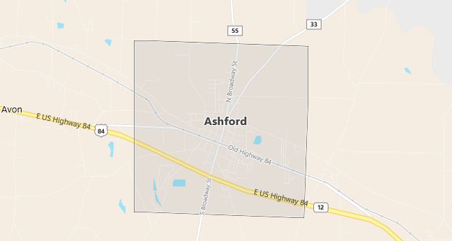
Moving to Ashford, Alabama
The current estimated population of Ashford is 2,200, with a gender distribution of 48% male and 52% female. The population has grown slowly, reflecting its role as a small town within the Dothan metropolitan area.
City Facts
- Year founded: 1891
- County: Houston County
- Land area: 6.0 square miles
- Population density: 367 people per square mile
- Area code: 334
- Zip code: 36312
Geography and Location
Ashford is located in southeastern Alabama, within Houston County, about 10 miles east of Dothan. The town is part of the Dothan metropolitan area, offering a rural setting with access to urban amenities. Ashford has a humid subtropical climate, characterized by hot, humid summers and mild winters. The town is accessible via U.S. Route 84, which provides easy connections to Dothan and other parts of southeastern Alabama. The local economy is based on agriculture, small businesses, and services for the surrounding rural communities. Ashford’s small-town atmosphere, combined with its proximity to Dothan, makes it an attractive place for families and retirees seeking a quieter, slower-paced lifestyle.
Demographics
Median resident age: 39.3 years
Median household income: $29,444
Median house value: $70,700
Population by Race
Races in Ashford:
- White Non-Hispanic (70.9%)
- Black (27.5%)
- Hispanic (1.5%)
- American Indian (0.8%)
Ancestries: United States (24.9%), Irish (6.7%), English (4.6%), German (2.7%), Scotch-Irish (1.6%).
Elevation: 276 feet
Land area: 6.1 square miles

Population by Education
For population 25 years and over in Ashford
- High school or higher: 71.3%
- Bachelor’s degree or higher: 12.7%
- Graduate or professional degree: 3.7%
- Unemployed: 6.3%
- Mean travel time to work: 24.0 minutes
For population 15 years and over in Ashford city
- Never married: 21.8%
- Now married: 55.8%
- Separated: 1.6%
- Widowed: 10.5%
- Divorced: 10.3%
0.5% Foreign born
Population change in the 1990s: -72 (-3.7%).
Hospitals
Hospitals/medical centers near Ashford:
- SOUTHEAST ALABAMA MEDICAL CENTER (about 9 miles; DOTHAN, AL)
- HEALTHSOUTH REHABILITATION HOSPITAL (about 12 miles; DOTHAN, AL)
- RAMSAY YOUTH SERVICES DOTHAN (about 12 miles; DOTHAN, AL)
Airports
Airports certified for carrier operations nearest to Ashford:
- DOTHAN RGNL (about 17 miles; DOTHAN, AL; Abbreviation: DHN)
- PANAMA CITY-BAY CO INTL (about 74 miles; PANAMA CITY, FL; Abbreviation: PFN)
- SOUTHWEST GEORGIA REGIONAL (about 77 miles; ALBANY, GA; Abbreviation: ABY)
Other public-use airports nearest to Ashford:
- HEADLAND MUNI (about 13 miles; HEADLAND, AL; Abbreviation: 0J6)
- MARIANNA MUNI (about 25 miles; MARIANNA, FL; Abbreviation: MAI)
- EARLY COUNTY (about 28 miles; BLAKELY, GA; Abbreviation: 11J)
Colleges and Universities
Colleges/universities with over 2000 students nearest to Ashford:
- GEORGE C WALLACE STATE COMMUNITY COLLEGE-DOTHAN (about 13 miles; DOTHAN, AL; Full-time enrollment: 2,703)
- TROY STATE UNIVERSITY-MAIN CAMPUS (about 67 miles; TROY, AL; Full-time enrollment: 9,143)
- GULF COAST COMMUNITY COLLEGE (about 76 miles; PANAMA CITY, FL; Full-time enrollment: 3,140)
- TALLAHASSEE COMMUNITY COLLEGE (about 81 miles; TALLAHASSEE, FL; Full-time enrollment: 7,016)
- FLORIDA STATE UNIVERSITY (about 83 miles; TALLAHASSEE, FL; Full-time enrollment: 29,949)
- ALBANY STATE UNIVERSITY (about 83 miles; ALBANY, GA; Full-time enrollment: 2,996)
- FLORIDA AGRICULTURAL AND MECHANICAL UNIVERSITY (about 84 miles; TALLAHASSEE, FL; Full-time enrollment: 10,991)
Schools
Public high schools in Ashford:
- ASHFORD HIGH SCHOOL (Students: 747; Location: 607 CHURCH ST; Grades: 07 – 12)
- HOUSTON COUNTY AREA VOCATIONAL CENTER (Location: 801 8TH AVE; Grades: 09 – 12)
Private high school in Ashford:
- ASHFORD ACADEMY (Students: 219; Location: 1100 N. BROADWAY ST.; Grades: KG – 12)
Public primary/middle school in Ashford:
- ASHFORD ELEMENTARY SCHOOL (Students: 868; Location: 100 BARFIELD ST; Grades: KG – 06)
