Moving to Ashland, Massachusetts
The current estimated population of Ashland is 18,800, with a gender distribution of 48% male and 52% female. The population has grown steadily, driven by suburban development and its location within the Greater Boston metropolitan area.
City Facts
- Year founded: 1846
- County: Middlesex County
- Land area: 12.9 square miles
- Population density: 1,456 people per square mile
- Area code: 508, 774
- Zip code: 01721
Geography and Location
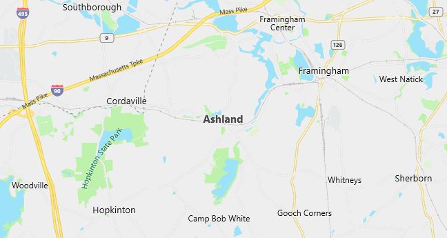
Ashland is located in eastern Massachusetts, within Middlesex County, about 22 miles west of downtown Boston. The town is part of the MetroWest region, known for its blend of suburban living and access to urban amenities. Ashland has a humid continental climate, with cold winters and warm summers. The town is accessible via major routes such as U.S. Route 135 and Interstate 90 (the Massachusetts Turnpike), providing easy commuting options to Boston and the surrounding areas. Ashland’s proximity to Boston, combined with its highly regarded schools, parks, and local attractions, such as the Ashland State Park, makes it a desirable place for families and professionals seeking suburban living with access to the city.
Demographics
Median resident age: 37.4 years
Median household income: $68,392
Median house value: $215,100
Population by Race
Races in Ashland:
- White Non-Hispanic (90.1%)
- Hispanic (2.9%)
- Two or more races (2.1%)
- Black (1.8%)
- Other race (1.7%)
- Asian Indian (1.1%)
- Chinese (0.8%)
Ancestries: Irish (24.8%), Italian (20.3%), English (15.6%), German (6.4%), French (5.6%), United States (5.4%).
Elevation: 188 feet

Population by Education
For population 25 years and over in Ashland
- High school or higher: 94.8%
- Bachelor’s degree or higher: 45.6%
- Graduate or professional degree: 19.1%
- Unemployed: 4.3%
- Mean travel time to work: 32.8 minutes
For population 15 years and over in Ashland town
- Never married: 22.8%
- Now married: 62.7%
- Separated: 1.2%
- Widowed: 4.2%
- Divorced: 9.0%
9.8% Foreign born (4.1% Europe, 2.5% Asia, 2.2% Latin America).
Hospitals
Hospitals/medical centers near Ashland:
- METROWEST MEDICAL CENTER (about 5 miles; FRAMINGHAM, MA)
- MARLBOROUGH HOSPITAL (about 9 miles; MARLBOROUGH, MA)
- MILFORD WHITINSVILLE REG HOSPITAL (about 9 miles; MILFORD, MA)
Airports
Airports certified for carrier operations nearest to Ashland:
- LAURENCE G HANSCOM FLD (about 19 miles; BEDFORD, MA; Abbreviation: BED)
- WORCESTER REGIONAL (about 28 miles; WORCESTER, MA; Abbreviation: ORH)
- GENERAL EDWARD LAWRENCE LOGAN INTL (about 33 miles; BOSTON, MA; Abbreviation: BOS)
Other public-use airports nearest to Ashland:
- MARLBORO (about 6 miles; MARLBORO, MA; Abbreviation: 9B1)
- HOPEDALE INDUSTRIAL PARK (about 12 miles; HOPEDALE, MA; Abbreviation: 1B6)
- NORFOLK (about 12 miles; NORFOLK, MA; Abbreviation: 32M)
Amtrak station near Ashland:
- 4 miles: FRAMINGHAM (443 WAVERLY ST.). Services: public payphones, snack bar, paid short-term parking, taxi stand, public transit connection.
Colleges and Universities
Colleges/universities with over 2000 students nearest to Ashland:
- FRAMINGHAM STATE COLLEGE (about 5 miles; FRAMINGHAM, MA; Full-time enrollment: 4,185)
- BRANDEIS UNIVERSITY (about 13 miles; WALTHAM, MA; Full-time enrollment: 4,444)
- WELLESLEY COLLEGE (about 14 miles; WELLESLEY, MA; Full-time enrollment: 2,241)
- MASSACHUSETTS BAY COMMUNITY COLLEGE (about 14 miles; WELLESLEY HILLS, MA; Full-time enrollment: 2,938)
- BENTLEY COLLEGE (about 20 miles; WALTHAM, MA; Full-time enrollment: 4,651)
- BOSTON COLLEGE (about 21 miles; CHESTNUT HILL, MA; Full-time enrollment: 13,341)
- MIDDLESEX COMMUNITY COLLEGE (about 21 miles; BEDFORD, MA; Full-time enrollment: 4,501)
Schools
Public high school in Ashland:
- ASHLAND HIGH (Students: 626; Location: 87 WEST UNION STREET; Grades: 09 – 12)
Public primary/middle schools in Ashland:
- HENRY E WARREN ELEM (Students: 616; Location: 73 FRUIT STREET; Grades: 01 – 03)
- DAVID MINDESS (Students: 605; Location: 90 CONCORD STREET; Grades: 04 – 06)
- ASHLAND MIDDLE (Students: 383; Location: 87 WEST UNION STREET; Grades: 07 – 08)
- WILLIAM PITTAWAY ELEM (Students: 360; Location: 75 CENTRAL STREET; Grades: PK – KG)
Private primary/middle schools in Ashland:
- PINCUSHION HILL MONTESSORI SCH (Students: 121; Location: 30 GREEN ST; Grades: PK – KG)
- METROWEST CHRISTIAN ACADEMY (Students: 120; Location: 280 PLEASANT STREET; Grades: PK – 6)
- JUST A WEE DAY CARE CENTER (Students: 99; Location: 300 ELIOT STREET; Grades: PK – KG)
- NEW COVENANT CHRISTIAN SCHOOL (Students: 82; Location: PO BOX 432; Grades: KG – 8)
Libraries
Library in Ashland:
- ASHLAND PUBLIC LIBRARY (Operating income: $247,957; Location: 66 FRONT ST.; 27,373 books; 654 audio materials; 1,195 video materials; 81 serial subscriptions)
