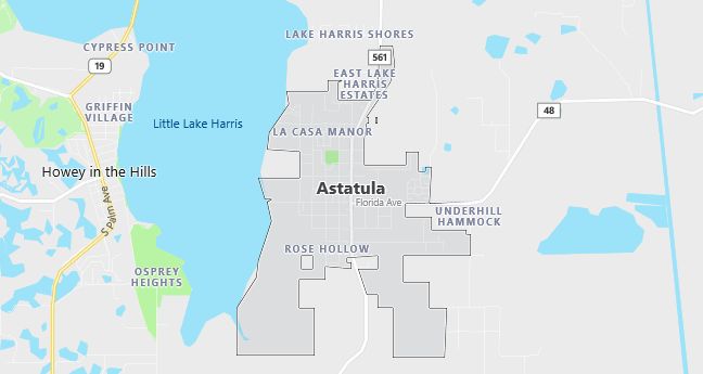
Moving to Astatula, Florida
The current estimated population of Astatula is 2,100, with males making up approximately 49% and females 51% of the population. The population has remained relatively stable over the past decade, with a slight increase due to local development. The town’s growth is slow but steady, driven by its proximity to nearby urban centers.
City Facts
- Year Founded: 1882
- County Affiliated: Lake County
- Land Area: 3.19 square miles
- Population Density: 657 people per square mile
- Area Code: 352
- Zip Codes: 34705
Geography and Location
Astatula is a small town located in Central Florida, nestled along the eastern shore of Little Lake Harris. It is approximately 35 miles northwest of Orlando, placing it within the Greater Orlando metropolitan area. The town enjoys a rural, tranquil environment with easy access to larger cities. Astatula is characterized by flat terrain typical of the Florida peninsula, with a mix of freshwater lakes and wetlands. The area experiences a humid subtropical climate, with hot summers and mild winters. Astatula’s location offers excellent opportunities for outdoor activities such as boating and fishing on nearby lakes, contributing to its appeal as a peaceful residential community with a close-knit population. The town is connected to major highways, making it accessible while maintaining a quiet, small-town atmosphere.
Demographics
Median resident age: 38.2 years
Median household income: $31,625
Median house value: $68,400
Population by Race
Races in Astatula:
- White Non-Hispanic (77.3%)
- Hispanic (19.4%)
- Other race (10.5%)
- Two or more races (3.1%)
- American Indian (1.5%)
- Black (1.2%)
(Total can be greater than 100% because Hispanics could be counted in other races)
Ancestries: United States (17.8%), German (15.9%), English (12.5%), Irish (8.5%), French (3.2%), Dutch (2.4%).
Elevation: 92 feet
Land area: 2.2 square miles

Population by Education
For population 25 years and over in Astatula
- High school or higher: 65.0%
- Bachelor’s degree or higher: 3.9%
- Graduate or professional degree: 1.8%
- Unemployed: 4.7%
- Mean travel time to work: 26.7 minutes
For population 15 years and over in Astatula town
- Never married: 17.5%
- Now married: 64.3%
- Separated: 2.6%
- Widowed: 6.9%
- Divorced: 8.6%
11.2% Foreign born (10.7% Latin America).
Population change in the 1990s: +303 (+30.5%).
Hospitals
Hospitals/medical centers near Astatula:
- LIFESTREAM BEHAVIORAL CENTER (about 9 miles; LEESBURG, FL)
- FLORIDA HOSPITAL/WATERMAN (about 11 miles; EUSTIS, FL)
- SOUTH LAKE HOSPITAL (about 12 miles; CLERMONT, FL)
Airports
Airports certified for carrier operations nearest to Astatula:
- ORLANDO SANFORD (about 35 miles; ORLANDO, FL; Abbreviation: SFB)
- ORLANDO INTL (about 37 miles; ORLANDO, FL; Abbreviation: MCO)
- OCALA INTL-JIM TAYLOR FIELD (about 46 miles; OCALA, FL; Abbreviation: OCF)
Other public-use airports nearest to Astatula:
- BOB WHITE FIELD (about 9 miles; ZELLWOOD, FL; Abbreviation: X61)
- LEESBURG REGIONAL (about 9 miles; LEESBURG, FL; Abbreviation: LEE)
- MID FLORIDA AIR SERVICE (about 12 miles; EUSTIS, FL; Abbreviation: X55)
Colleges and Universities
Colleges/universities with over 2000 students nearest to Astatula:
- UNIVERSITY OF PHOENIX-ORLANDO CAMPUS (about 27 miles; MAITLAND, FL; Full-time enrollment: 3,992)
- ROLLINS COLLEGE (about 28 miles; WINTER PARK, FL; Full-time enrollment: 2,899)
- VALENCIA COMMUNITY COLLEGE (about 31 miles; ORLANDO, FL; Full-time enrollment: 15,792)
- SEMINOLE COMMUNITY COLLEGE (about 32 miles; SANFORD, FL; Full-time enrollment: 5,261)
- UNIVERSITY OF CENTRAL FLORIDA (about 35 miles; ORLANDO, FL; Full-time enrollment: 26,717)
- STETSON UNIVERSITY (about 35 miles; DELAND, FL; Full-time enrollment: 2,966)
- CENTRAL FLORIDA COMMUNITY COLLEGE (about 44 miles; OCALA, FL; Full-time enrollment: 3,101)
Public primary/middle school in Astatula:
- ASTATULA ELEMENTARY SCHOOL (Students: 704; Location: 13925 FLORIDA AVENUE; Grades: PK – 05)
