Moving to Atascadero, California
The current estimated population of Atascadero is 30,000, with males comprising approximately 49% and females 51%. The population has steadily increased in recent years, driven by a growing residential base and its proximity to both the California Central Coast and inland cities.
City Facts
- Year Founded: 1913
- County Affiliated: San Luis Obispo County
- Land Area: 26.13 square miles
- Population Density: 1,148 people per square mile
- Area Code: 805
- Zip Codes: 93422, 93423
Geography and Location
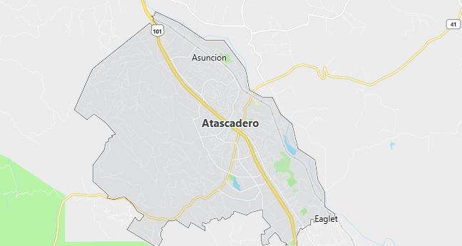
Atascadero is located in the northern part of San Luis Obispo County, along California’s scenic Central Coast. It is situated halfway between the cities of San Francisco and Los Angeles, making it an attractive location for residents seeking a more rural lifestyle while maintaining access to major urban areas. The town is characterized by rolling hills, oak woodlands, and a Mediterranean climate with hot, dry summers and mild, wet winters. Atascadero’s geography is diverse, featuring vineyards, ranches, and open spaces that provide a variety of outdoor recreational opportunities, including hiking, biking, and wine tasting. The town is bordered by the coastal city of Morro Bay to the west and the agricultural-rich Salinas Valley to the east. Atascadero’s proximity to both the Pacific Ocean and the inland mountains makes it a hub for tourists exploring California’s diverse landscapes. The city’s economy has historically been supported by agriculture, tourism, and small businesses, but recent years have seen growth in the tech and service industries, driven by its desirable location and quality of life.
Demographics
Median resident age: 38.2 years
Median household income: $48,725
Median house value: $201,600
Population by Race
Races in Atascadero:
- White Non-Hispanic (82.7%)
- Hispanic (10.5%)
- Two or more races (3.3%)
- Other race (3.2%)
- Black (2.4%)
- American Indian (2.2%)
(Total can be greater than 100% because Hispanics could be counted in other races)
Ancestries: German (17.1%), English (16.4%), Irish (14.2%), Italian (6.7%), United States (6.0%), French (3.7%).
Elevation: 880 feet
Land area: 26.7 square miles

Population by Education
For population 25 years and over in Atascadero
- High school or higher: 88.4%
- Bachelor’s degree or higher: 20.3%
- Graduate or professional degree: 5.5%
- Unemployed: 4.3%
- Mean travel time to work: 22.3 minutes
For population 15 years and over in Atascadero city
- Never married: 22.0%
- Now married: 57.8%
- Separated: 2.1%
- Widowed: 6.1%
- Divorced: 12.0%
4.4% Foreign born (1.8% Latin America, 1.0% Europe, 0.9% Asia, 0.6% North America).
Population change in the 1990s: +3,074 (+13.2%).
Hospitals
Hospitals/medical centers near Atascadero:
- TWIN CITIES COMMUNITY HOSPITAL (about 6 miles; TEMPLETON, CA)
- SIERRA VISTA REGIONAL MEDICAL CENTER (about 15 miles; SAN LUIS OBISPO, CA)
- FRENCH HOSPITAL MEDICAL CENTER (about 16 miles; SAN LUIS OBISPO, CA)
Airports
Airports certified for carrier operations nearest to Atascadero:
- PASO ROBLES MUNI (about 14 miles; PASO ROBLES, CA; Abbreviation: PRB)
- SAN LUIS COUNTY REGIONAL (about 18 miles; SAN LUIS OBISPO, CA; Abbreviation: SBP)
- SANTA MARIA PUB/CAPT G ALLAN HANCOCK FLD (about 45 miles; SANTA MARIA, CA; Abbreviation: SMX)
Other public-use airports nearest to Atascadero:
- OCEANO COUNTY (about 27 miles; OCEANO, CA; Abbreviation: L52)
- TUSI AHP (HUNTER LIGGETT) (about 52 miles; FORT HUNTER LIGGET JOLON, CA; Abbreviation: HGT)
- NEW COALINGA MUNI (about 54 miles; COALINGA, CA; Abbreviation: C80)
Amtrak station:
ATASCADERO (EAST MALL & PALMA AVE.) – Bus Station. Services: fully wheelchair accessible, public payphones, taxi stand.
Colleges and Universities
Colleges/Universities in Atascadero:
- CAREER TRAINING CENTER (Full-time enrollment: 25; Location: 4885 EL CAMINO REAL; Public; Website: ctraining.org)
- WEST COAST SCHOOLS (Location: 5385 EL CAMINO REAL; Private, for-profit)
Colleges and Universities
Colleges/universities with over 2000 students nearest to Atascadero:
- CALIFORNIA POLYTECHNIC STATE UNIV-SAN LUIS OBISPO (about 18 miles; SAN LUIS OBISPO, CA; Full-time enrollment: 15,985)
- CUESTA COLLEGE (about 18 miles; SAN LUIS OBISPO, CA; Full-time enrollment: 6,121)
- ALLAN HANCOCK COLLEGE (about 46 miles; SANTA MARIA, CA; Full-time enrollment: 6,037)
- WEST HILLS COMMUNITY COLLEGE (about 55 miles; COALINGA, CA; Full-time enrollment: 2,406)
- TAFT COLLEGE (about 89 miles; Taft, CA; Full-time enrollment: 2,801)
- UNIVERSITY OF CALIFORNIA-SANTA BARBARA (about 93 miles; SANTA BARBARA, CA; Full-time enrollment: 19,420)
- SANTA BARBARA CITY COLLEGE (about 100 miles; SANTA BARBARA, CA; Full-time enrollment: 8,137)
Schools
Public high schools in Atascadero:
- ATASCADERO HIGH (Students: 1,717; Location: 1 HIGH SCHOOL HILL; Grades: 09 – 12)
- DEL RIO CONTINUATION HIGH SCHOOL (Students: 94; Location: 4507 DEL RIO ROAD; Grades: 10 – 12)
Private high school in Atascadero:
- NORTH COUNTY CHRISTIAN SCHOOL (Students: 329; Location: 6225 ATASCADERO MALL/DRWR 6017; Grades: KG – 12)
Public primary/middle schools in Atascadero:
- ATASCADERO JUNIOR HIGH (Students: 796; Location: 6501 LEWIS AVE.; Grades: 07 – 08)
- SAN GABRIEL ELEMENTARY (Students: 574; Location: 8500 SAN GABRIEL ROAD; Grades: KG – 06)
- SAN BENITO ELEMENTARY (Students: 558; Location: 4300 DEL RIO; Grades: KG – 06)
- SANTA ROSA ROAD ACADEMIC ACADEMY (Students: 545; Location: 8655 SANTA ROSA ROAD; Grades: KG – 06)
- MONTEREY ROAD ELEMENTARY (Students: 467; Location: 3355 MONTEREY ROAD; Grades: KG – 06)
- FINE ARTS ACADEMY (Students: 154; Location: 600 OLMEDA AVE.; Grades: 04 – 08)
- WEST MALL ALTERNATIVE (Students: 131; Location: 6495 LEWIS AVE.; Grades: KG – 12)
Private primary/middle schools in Atascadero:
- CHILDREN’S HOUSE MONTESSORI SC (Students: 96; Location: 3025 MONTEREY ROAD; Grades: PK – 5)
- CLASSICAL COTTAGE SCHOOL INC (Students: 16; Location: 5235 PALMA AVE; Grades: UG – UG)
- LATIN (Students: 10; Location: 4500 EL CAMINO REAL; Grades: 6 – 8; Girls only)
