Moving to Athol, Massachusetts
The current estimated population of Athol is 11,500, with males making up 49% and females 51%. The population has remained stable, with a slight increase due to local economic development and the appeal of small-town life.
City Facts
- Year Founded: 1762
- County Affiliated: Worcester County
- Land Area: 33.4 square miles
- Population Density: 345 people per square mile
- Area Code: 978
- Zip Codes: 01331
Geography and Location
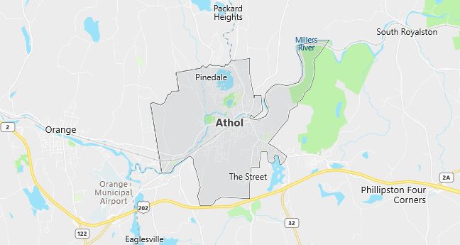
Athol is a small town located in north-central Massachusetts, approximately 70 miles west of Boston and 30 miles northeast of Springfield. The town is situated along the Millers River, which historically powered its mills and factories. Today, Athol is known for its natural beauty and access to outdoor activities, with numerous parks, forests, and hiking trails nearby, including the popular Bearsden Forest Conservation Area. The town experiences a humid continental climate, with cold, snowy winters and warm summers. Athol’s economy has historically been based on manufacturing, but in recent years, it has diversified to include small businesses and services. Its location near major highways, such as Route 2, provides easy access to larger cities while maintaining its small-town charm. The community is known for its historic downtown, local festivals, and a strong sense of tradition, making it an attractive place for families and individuals looking for a peaceful and supportive environment. Athol’s combination of history, natural beauty, and community spirit continues to make it a desirable place to live.
Demographics
Median resident age: 38.6 years
Median household income: $33,475
Median house value: $87,100
Population by Race
Races in Athol:
- White Non-Hispanic (95.3%)
- Hispanic (2.0%)
- Two or more races (1.5%)
- American Indian (1.0%)
- Other race (0.7%)
- Black (0.7%)
Ancestries: French (20.6%), English (16.2%), Irish (13.0%), French Canadian (12.7%), Italian (11.7%), German (5.1%).
Elevation: 546 feet
Land area: 8.3 square miles

Population by Education
For population 25 years and over in Athol
- High school or higher: 80.0%
- Bachelor’s degree or higher: 13.3%
- Graduate or professional degree: 4.2%
- Unemployed: 4.5%
- Mean travel time to work: 24.6 minutes
For population 15 years and over in Athol town
- Never married: 23.9%
- Now married: 54.3%
- Separated: 2.4%
- Widowed: 8.9%
- Divorced: 10.4%
2.8% Foreign born (1.6% North America, 0.8% Europe, 0.3% Latin America).
Hospitals
Hospital/medical center in Athol:
- ATHOL MEMORIAL HOSPITAL (2033 MAIN STREET)
Other hospitals/medical centers near Athol:
- HEYWOOD HOSPITAL (about 17 miles; GARDNER, MA)
- MARY LANE HOSPITAL (about 23 miles; WARE, MA)
- UNIVERSITY HEALTH SERVICES (about 24 miles; AMHERST, MA)
Airports
Airports certified for carrier operations nearest to Athol:
- WORCESTER REGIONAL (about 34 miles; WORCESTER, MA; Abbreviation: ORH)
- WESTOVER ARB/METROPOLITAN (about 36 miles; SPRINGFIELD/CHICOPEE, MA; Abbreviation: CEF)
- BARNES MUNI (about 45 miles; WESTFIELD/SPRINGFIELD, MA; Abbreviation: BAF)
Other public-use airports nearest to Athol:
- ORANGE MUNI (about 5 miles; ORANGE, MA; Abbreviation: ORE)
- GARDNER MUNI (about 17 miles; GARDNER, MA; Abbreviation: GDM)
- TANNER-HILLER (about 19 miles; BARRE/BARRE PLAINS, MA; Abbreviation: 8B5)
Colleges and Universities
Colleges/universities with over 2000 students nearest to Athol:
- MOUNT WACHUSETT COMMUNITY COLLEGE (about 17 miles; GARDNER, MA; Full-time enrollment: 2,023)
- KEENE STATE COLLEGE (about 25 miles; KEENE, NH; Full-time enrollment: 4,049)
- FITCHBURG STATE COLLEGE (about 30 miles; FITCHBURG, MA; Full-time enrollment: 3,660)
- UNIVERSITY OF MASSACHUSETTS-AMHERST (about 32 miles; AMHERST, MA; Full-time enrollment: 21,468)
- SMITH COLLEGE (about 35 miles; NORTHAMPTON, MA; Full-time enrollment: 3,053)
- WORCESTER STATE COLLEGE (about 35 miles; WORCESTER, MA; Full-time enrollment: 3,846)
- MOUNT HOLYOKE COLLEGE (about 35 miles; SOUTH HADLEY, MA; Full-time enrollment: 2,029)
Schools
Public high school in Athol:
- ATHOL HIGH (Students: 607; Location: 2363 MAIN STREET; Grades: 09 – 12)
Public primary/middle schools in Athol:
- ATHOL-ROYALSTON MIDDLE SCHOOL (Students: 517; Location: 1062 PLEASANT STREET; Grades: 06 – 08)
- RIVERBEND (Students: 301; Location: 174 RIVERBEND STREET; Grades: KG – 05)
- PLEASANT ST (Students: 282; Location: 1060 PLEASANT STREET; Grades: KG – 05)
- SANDERS STREET (Students: 174; Location: 314 SANDERS STREET; Grades: KG – 03)
- SILVER LAKE (Students: 132; Location: 245 SILVER LAKE; Grades: PK – 03)
- ELLEN BIGELOW (Students: 69; Location: 129 ALLEN STREET; Grades: PK – 12)
Libraries
Library in Athol:
- ATHOL PUBLIC LIBRARY (Operating income: $355,118; Location: 568 MAIN ST.; 44,816 books; 1,585 audio materials; 2,284 video materials; 95 serial subscriptions)
