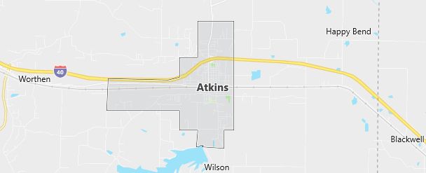
Moving to Atkins, Arkansas
The current estimated population of Atkins, Arkansas, is 3,160, including male and female residents in roughly equal percentages (48% male and 52% female). The population has seen minor fluctuations over the years, with a slight decrease due to urban migration trends. Overall, the community remains stable, with gradual growth anticipated due to regional development and new housing projects.
City Facts
- Year Founded: 1872
- County Affiliation: Pope County
- Land Area: 6.4 square miles
- Population Density: 492 people per square mile
- Area Code: 479
- Zip Codes: 72823
Geography and Location
Atkins, Arkansas, is located in Pope County, in the heart of the Arkansas River Valley. Nestled between the Ozark and Ouachita mountain ranges, this small town enjoys a scenic backdrop of rolling hills and fertile farmland. The city’s geography is defined by its proximity to Lake Atkins, a popular recreational spot that offers fishing, boating, and camping activities for both residents and visitors.
Atkins lies just off Interstate 40, providing easy access to larger cities such as Little Rock (about 65 miles to the southeast) and Fort Smith (about 85 miles to the west). The town benefits from a temperate climate, with hot summers and mild winters typical of the region. The surrounding area is predominantly agricultural, with many farms and ranches contributing to the local economy. Due to its strategic location near the Arkansas River, Atkins has historically been a hub for transportation and trade, though its role in commerce has shifted in modern times to focus more on regional services and small-scale manufacturing.
Demographics
Median resident age: 37.2 years
Median household income: $30,339
Median house value: $54,400
Population by Race
Races in Atkins:
- White Non-Hispanic (96.5%)
- American Indian (1.4%)
- Hispanic (0.9%)
- Two or more races (0.9%)
- Black (0.9%)
Ancestries: United States (23.9%), Irish (13.8%), German (10.4%), English (2.5%), Dutch (2.2%), French (1.9%).
Elevation: 369 feet
Land area: 6.1 square miles

Population by Education
For population 25 years and over in Atkins
- High school or higher: 70.0%
- Bachelor’s degree or higher: 9.5%
- Graduate or professional degree: 2.8%
- Unemployed: 3.3%
- Mean travel time to work: 22.6 minutes
For population 15 years and over in Atkins city
- Never married: 16.9%
- Now married: 59.9%
- Separated: 1.4%
- Widowed: 10.0%
- Divorced: 11.9%
0.3% Foreign born
Population change in the 1990s: -163 (-5.4%).
Hospitals
Hospitals/medical centers near Atkins:
- ST ANTHONY’S HEALTHCARE CENTER (about 14 miles; MORRILTON, AR)
- ST MARYS REGIONAL MEDICAL CENTER (about 14 miles; RUSSELLVILLE, AR)
- DARDANELLE HOSPITAL (about 17 miles; DARDANELLE, AR)
Airports
Airports certified for carrier operations nearest to Atkins:
- MEMORIAL FIELD (about 55 miles; HOT SPRINGS, AR; Abbreviation: HOT)
- LITTLE ROCK AFB (about 61 miles; JACKSONVILLE, AR; Abbreviation: LRF)
- ADAMS FIELD (about 62 miles; LITTLE ROCK, AR; Abbreviation: LIT)
Other public-use airports nearest to Atkins:
- PETIT JEAN PARK (about 9 miles; MORRILTON, AR; Abbreviation: MPJ)
- RUSSELLVILLE RGNL (about 11 miles; RUSSELLVILLE, AR; Abbreviation: RUE)
- MORRILTON MUNI (about 19 miles; MORRILTON, AR; Abbreviation: BDQ)
Colleges and Universities
Colleges/universities with over 2000 students nearest to Atkins:
- ARKANSAS TECH UNIVERSITY (about 14 miles; RUSSELLVILLE, AR; Full-time enrollment: 4,450)
- UNIVERSITY OF CENTRAL ARKANSAS (about 42 miles; CONWAY, AR; Full-time enrollment: 7,693)
- UNIVERSITY OF ARKANSAS AT LITTLE ROCK (about 55 miles; LITTLE ROCK, AR; Full-time enrollment: 8,024)
- ARKANSAS STATE UNIVERSITY-BEEBE BRANCH (about 73 miles; BEEBE, AR; Full-time enrollment: 3,840)
- HENDERSON STATE UNIVERSITY (about 84 miles; ARKADELPHIA, AR; Full-time enrollment: 3,109)
- HARDING UNIVERSITY (about 84 miles; SEARCY, AR; Full-time enrollment: 3,959)
- WESTARK COLLEGE (about 90 miles; FT SMITH, AR; Full-time enrollment: 3,472)
Schools
Public high school in Atkins:
- ATKINS HIGH SCHOOL (Students: 351; Location: 403 AVENUE THREE NW; Grades: 09 – 12)
Public primary/middle schools in Atkins:
- ATKINS ELEMENTARY SCHOOL (Students: 377; Location: 302 NW 5TH STREET; Grades: KG – 04)
- ATKINS MIDDLE SCHOOL (Students: 356; Location: 302 AVENUE TWO, NW; Grades: 05 – 08)
