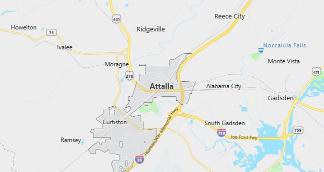
Moving to Attalla, Alabama
The current estimated population of Attalla, Alabama, is 5,950, with 48% male and 52% female. The population has remained stable, supported by its historical significance and role as a regional hub in northeastern Alabama.
City Facts
- Year Founded: 1870
- County Affiliation: Etowah County
- Land Area: 7.1 square miles
- Population Density: 837 people per square mile
- Area Code: 256
- Zip Codes: 35954
Geography and Location
Attalla, Alabama, is located in Etowah County, in the northeastern part of the state. It sits near the Coosa River and is part of the larger Gadsden metropolitan area. Attalla is positioned along U.S. Highway 431 and Interstate 59, making it a well-connected town with access to both Birmingham and Chattanooga, Tennessee.
The geography of Attalla is characterized by the foothills of the Appalachian Mountains, providing a hilly and scenic landscape. The surrounding area is rich in natural beauty, with numerous parks, rivers, and outdoor recreational opportunities. Attalla has a mix of residential, commercial, and industrial areas, with a history rooted in the iron and steel industries.
Attalla experiences a humid subtropical climate, with hot summers and mild winters. The town is known for its historic downtown area, which features several well-preserved buildings from the late 19th and early 20th centuries. Its location and historical significance as a transportation and industrial hub have contributed to its continued role as a small but important community in northeastern Alabama.
Demographics
Median resident age: 38.1 years
Median household income: $27,444
Median house value: $51,800
Population by Race
Races in Attalla:
- White Non-Hispanic (83.3%)
- Black (13.2%)
- Hispanic (2.5%)
- Other race (1.6%)
- Two or more races (0.7%)
- American Indian (0.6%)
Ancestries: United States (25.7%), Irish (10.0%), English (5.7%), German (4.9%), Scotch-Irish (2.2%), Dutch (1.5%).
Elevation: 550 feet
Land area: 6.7 square miles

Population by Education
For population 25 years and over in Attalla
- High school or higher: 68.8%
- Bachelor’s degree or higher: 6.9%
- Graduate or professional degree: 2.3%
- Unemployed: 4.5%
- Mean travel time to work: 22.8 minutes
For population 15 years and over in Attalla city
- Never married: 18.4%
- Now married: 53.6%
- Separated: 3.4%
- Widowed: 10.0%
- Divorced: 14.6%
1.4% Foreign born
Population change in the 1990s: -554 (-7.8%).
Hospitals
Hospitals/medical centers near Attalla:
- RIVERVIEW REGIONAL MEDICAL CENTER (about 8 miles; GADSDEN, AL)
- GADSDEN REGIONAL MEDICAL CENTER (about 13 miles; GADSDEN, AL)
- HEALTHSOUTH REHABILITATION HOSPITAL (about 13 miles; GADSDEN, AL)
Airports
Airports certified for carrier operations nearest to Attalla:
- TALLADEGA MUNI (about 31 miles; TALLADEGA, AL; Abbreviation: ASN)
- ANNISTON METROPOLITAN (about 34 miles; ANNISTON, AL; Abbreviation: ANB)
- BIRMINGHAM INTL (about 56 miles; BIRMINGHAM, AL; Abbreviation: BHM)
Other public-use airports nearest to Attalla:
- GADSDEN MUNI (about 4 miles; GADSDEN, AL; Abbreviation: GAD)
- THE ALBERTVILLE MUNI-THOMAS J BRUMLIK FLD (about 18 miles; ALBERTVILLE, AL; Abbreviation: 8A0)
- ROBBINS FIELD (about 19 miles; ONEONTA, AL; Abbreviation: 20A)
Colleges and Universities
Colleges/universities with over 2000 students nearest to Attalla:
- GADSDEN STATE COMMUNITY COLLEGE (about 21 miles; GADSDEN, AL; Full-time enrollment: 3,360)
- JACKSONVILLE STATE UNIVERSITY (about 27 miles; JACKSONVILLE, AL; Full-time enrollment: 6,418)
- JEFFERSON STATE COMMUNITY COLLEGE (about 49 miles; BIRMINGHAM, AL; Full-time enrollment: 3,279)
- GEORGE C WALLACE STATE COMMUNITY COLL-HANCEVILLE (about 50 miles; HANCEVILLE, AL; Full-time enrollment: 3,272)
- ALABAMA A & M UNIVERSITY (about 58 miles; NORMAL, AL; Full-time enrollment: 4,886)
- SAMFORD UNIVERSITY (about 61 miles; BIRMINGHAM, AL; Full-time enrollment: 4,106)
- UNIVERSITY OF ALABAMA IN HUNTSVILLE (about 63 miles; HUNTSVILLE, AL; Full-time enrollment: 4,795)
Schools
Public high schools in Attalla:
- ETOWAH HIGH SCHOOL (Students: 683; Location: 201 CASE AVE.; Grades: 09 – 12)
- CAREER TECHNICAL CENTER (Students: 13; Location: 105 BURKE AVE SE; Grades: 10 – 12)
Public primary/middle schools in Attalla:
- ETOWAH MIDDLE SCHOOL (Students: 525; Location: 429 S 4TH ST; Grades: 06 – 08)
- CURTISTON PRIMARY SCHOOL (Students: 320; Location: 1 CULLMAN AVE; Grades: PK – 02)
- STOWERS HILL INTERMEDIATE SCHOOL (Students: 295; Location: 404 9TH AVE W; Grades: 03 – 05)
- IVALEE ELEMENTARY SCHOOL (Students: 265; Location: 840 GALLANT RD; Grades: KG – 06)
- DUCK SPRINGS ELEMENTARY SCHOOL (Students: 239; Location: 10180 DUCK SPRINGS RD; Grades: KG – 06)
- ETOWAH COUNTY ALTERNATIVE SCHOOL (Location: 106 BURKE AVE. S.E.; Grades: 04 – 12)
Libraries
Library in Attalla:
- ATTALLA-ETOWAH CO. PUBLIC LIBRARY (Operating income: $89,524; Location: 604 NORTH 4TH STREET; 24,622 books; 227 audio materials; 82 serial subscriptions)
