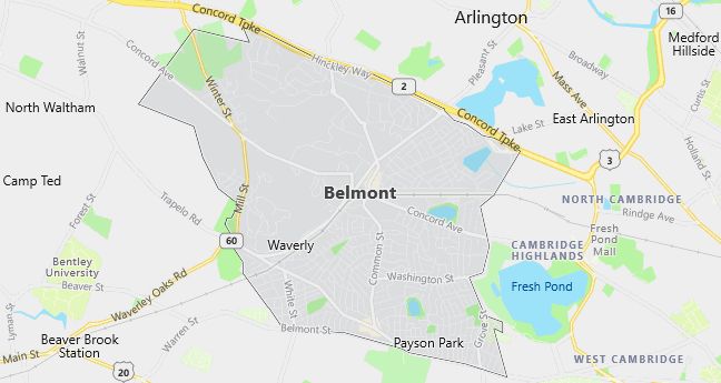
Moving to Belmont, Massachusetts
Population: 24,194. Estimated population in July 2024: 23,371 (-3.4% change)
Males: 11,292 (46.7%), Females: 12,902 (53.3%)
Middlesex County
Demographics
Median resident age: 40.4 years
Median household income: $80,295
Median house value: $450,000
Population by Race
Races in Belmont:
- White Non-Hispanic (89.8%)
- Chinese (2.8%)
- Hispanic (1.8%)
- Two or more races (1.4%)
- Black (1.1%)
- Japanese (0.9%)
- Korean (0.8%)
- Asian Indian (0.8%)
Ancestries: Irish (24.8%), Italian (16.4%), English (11.2%), German (8.1%), French (3.6%), Russian (3.4%).
Elevation: 44 feet
Land area: 4.7 square miles

Population by Education
For population 25 years and over in Belmont
- High school or higher: 94.6%
- Bachelor’s degree or higher: 63.1%
- Graduate or professional degree: 36.7%
- Unemployed: 2.3%
- Mean travel time to work: 26.4 minutes
For population 15 years and over in Belmont town
- Never married: 29.4%
- Now married: 57.1%
- Separated: 1.0%
- Widowed: 6.8%
- Divorced: 5.8%
14.8% Foreign born (6.2% Asia, 6.0% Europe).
Hospitals
Hospital/medical center in Belmont:
- MCLEAN HOSPITAL CORPORATION (115 MILL ST)
Other hospitals/medical centers near Belmont:
- KINDRED HOSPITAL – BOSTON (about 4 miles; BOSTON, MA)
- FRANCISCAN CHILDRENS HOSP & REHAB CTR (about 4 miles; BRIGHTON, MA)
- ST ELIZABETHS MEDICAL CENTER OF BOSTON (about 4 miles; BRIGHTON, MA)
Airports
Airports certified for carrier operations nearest to Belmont:
- LAURENCE G HANSCOM FLD (about 10 miles; BEDFORD, MA; Abbreviation: BED)
- GENERAL EDWARD LAWRENCE LOGAN INTL (about 13 miles; BOSTON, MA; Abbreviation: BOS)
- MANCHESTER (about 42 miles; MANCHESTER, NH; Abbreviation: MHT)
Other public-use airports nearest to Belmont:
- NORWOOD MEMORIAL (about 15 miles; NORWOOD, MA; Abbreviation: OWD)
- MERRIMACK VALLEY (about 22 miles; METHUEN, MA; Abbreviation: MA2)
- LAWRENCE MUNI (about 23 miles; LAWRENCE, MA; Abbreviation: LWM)
Amtrak stations near Belmont:
- 8 miles: BACK BAY (BOSTON, 145 DARTMOUTH ST.). Services: ticket office, partially wheelchair accessible, enclosed waiting area, public restrooms, public payphones, vending machines, ATM, paid short-term parking, paid long-term parking, call for car rental service, taxi stand, public transit connection.
- 8 miles: BOSTON, NORTH STATION (BOSTON, 126 CAUSEWAY ST.). Services: ticket office, enclosed waiting area.
- 9 miles: BOSTON (SO. STA) (BOSTON, ATLANTIC AVE. & SUMMER ST.). Services: ticket office, fully wheelchair accessible, enclosed waiting area, public restrooms, public payphones, full-service food facilities and snack bar, ATM, paid short-term parking, paid long-term parking, call for car rental service, taxi stand, intercity bus service, public transit connection.
Colleges and Universities
Colleges/universities with over 2000 students nearest to Belmont:
- BENTLEY COLLEGE (about 4 miles; WALTHAM, MA; Full-time enrollment: 4,651)
- HARVARD UNIVERSITY (about 4 miles; CAMBRIDGE, MA; Full-time enrollment: 20,531)
- LESLEY UNIVERSITY (about 4 miles; CAMBRIDGE, MA; Full-time enrollment: 3,700)
- BOSTON COLLEGE (about 5 miles; CHESTNUT HILL, MA; Full-time enrollment: 13,341)
- TUFTS UNIVERSITY (about 5 miles; MEDFORD, MA; Full-time enrollment: 8,627)
- MASSACHUSETTS INSTITUTE OF TECHNOLOGY (about 6 miles; CAMBRIDGE, MA; Full-time enrollment: 9,895)
- BOSTON UNIVERSITY (about 6 miles; BOSTON, MA; Full-time enrollment: 25,110)
Schools
Public high school in Belmont:
- BELMONT HIGH (Students: 1,140; Location: 221 CONCORD AVENUE; Grades: 09 – 12)
Private high schools in Belmont:
- BELMONT HILL SCHOOL (Students: 434; Location: 350 PROSPECT ST; Grades: 7 – 12; Boys only)
- THE ARLINGTON SCHOOL (Students: 41; Location: 115 MILL ST; Grades: 8 – 12)
Public primary/middle schools in Belmont:
- WINTHROP L CHENERY MIDDLE (Students: 1,174; Location: 95 WASHINGTON STREET; Grades: 05 – 08)
- WINN BROOK (Students: 431; Location: 97 WATERHOUSE RD; Grades: PK – 04)
- ROGER E WELLINGTON (Students: 427; Location: 121 ORCHARD STREET; Grades: KG – 04)
- MARY LEE BURBANK (Students: 302; Location: 266 SCHOOL STREET; Grades: KG – 04)
- DANIEL BUTLER (Students: 239; Location: 90 WHITE STREET; Grades: KG – 04)
- EAST DISTRICT (Location: P.O.BOX 79180; Grades: 00 – 00)
Private primary/middle schools in Belmont:
- BELMONT DAY SCHOOL (Students: 177; Location: 55 DAY SCHOOL LANE; Grades: PK – 6)
- BARLTETT SCHOOL (Students: 87; Location: 132 LEXINGTON ST; Grades: PK – 6)
- CORNERSTONE CHRISTIAN ACADEMY (Students: 35; Location: P O BOX 438/ 54 BRIGHTON; Grades: KG – 10)
- THE KENDALL SCHOOL (Students: 10; Location: 577 BELMONT STREET/PO BOX 17; Grades: PK – KG)
Libraries
Library in Belmont:
- BELMONT PUBLIC LIBRARY (Operating income: $1,434,096; Location: 336 CONCORD AVE.; 159,551 books; 4,673 audio materials; 4,658 video materials; 404 serial subscriptions)
