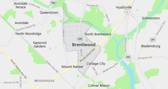
Moving to Brentwood, Maryland
Population: 2,844. Estimated population in July 2024: 2,937 (+3.3% change)
Males: 1,396 (49.1%), Females: 1,448 (50.9%)
Zip code: 20722
Demographics
Median resident age: 31.6 years
Median household income: $45,427
Median house value: $111,300
Population by Race
Races in Brentwood:
- Black (49.8%)
- Hispanic (23.6%)
- White Non-Hispanic (22.6%)
- Other race (15.0%)
- Two or more races (4.0%)
- American Indian (1.6%)
- Filipino (1.0%)
- Chinese (0.6%)
(Total can be greater than 100% because Hispanics could be counted in other races)
Ancestries: Subsaharan African (7.1%), Irish (5.9%), West Indian (5.6%), United States (4.3%), German (2.8%), Italian (1.5%).
Land area: 0.4 square miles

Population by Education
For population 25 years and over in Brentwood
- High school or higher: 66.4%
- Bachelor’s degree or higher: 14.0%
- Graduate or professional degree: 5.0%
- Unemployed: 5.1%
- Mean travel time to work: 33.6 minutes
For population 15 years and over in Brentwood town
- Never married: 38.1%
- Now married: 40.0%
- Separated: 5.0%
- Widowed: 4.7%
- Divorced: 12.2%
29.3% Foreign born (22.7% Latin America, 4.6% Africa).
Population change in the 1990s: -42 (-1.5%).
Hospitals
Hospitals/medical centers near Brentwood:
- PROVIDENCE HOSPITAL (about 3 miles; WASHINGTON, DC)
- MEDLINK HOSPITAL OF CAPITOL HILL (about 4 miles; WASHINGTON, DC)
- WASHINGTON ADVENTIST HOSP (about 5 miles; TAKOMA PARK, MD)
Airports
Airports certified for carrier operations nearest to Brentwood:
- RONALD REAGAN WASHINGTON NATIONAL (about 9 miles; WASHINGTON, DC; Abbreviation: DCA)
- ANDREWS AFB (about 12 miles; CAMP SPRINGS, MD; Abbreviation: ADW)
- BALTIMORE-WASHINGTON INTL (about 26 miles; BALTIMORE, MD; Abbreviation: BWI)
Other public-use airports nearest to Brentwood:
- COLLEGE PARK (about 4 miles; COLLEGE PARK, MD; Abbreviation: CGS)
- SOUTH CAPITOL STREET (about 7 miles; WASHINGTON, DC; Abbreviation: 09W)
- SUBURBAN (about 13 miles; LAUREL, MD; Abbreviation: W18)
Amtrak stations near Brentwood:
- 5 miles: WASHINGTON (50 MASSACHUSETTS AVE. N.E.). Services: ticket office, fully wheelchair accessible, enclosed waiting area, public restrooms, public payphones, full-service food facilities and snack bar, ATM, paid short-term parking, paid long-term parking, car rental agency, taxi stand, public transit connection.
- 7 miles: NEW CARROLLTON (4300 GARDEN CITY DR.). Services: ticket office, fully wheelchair accessible, enclosed waiting area, public restrooms, public payphones, snack bar, ATM, paid short-term parking, paid long-term parking, call for car rental service, taxi stand, public transit connection.
- 12 miles: ALEXANDRIA (110 CALLAHAN DR.). Services: ticket office, partially wheelchair accessible, enclosed waiting area, public restrooms, public payphones, vending machines, ATM, free short-term parking, free long-term parking, call for car rental service, call for taxi service, public transit connection.
Colleges and Universities
Colleges/universities with over 2000 students nearest to Brentwood:
- CATHOLIC UNIVERSITY OF AMERICA (about 3 miles; WASHINGTON, DC; Full-time enrollment: 4,472)
- UNIVERSITY OF MARYLAND-UNIVERSITY COLLEGE (about 4 miles; Adelphi, MD; Full-time enrollment: 8,434)
- GEORGETOWN UNIVERSITY (about 6 miles; WASHINGTON, DC; Full-time enrollment: 11,674)
- HOWARD UNIVERSITY (about 6 miles; WASHINGTON, DC; Full-time enrollment: 9,297)
- GEORGE WASHINGTON UNIVERSITY (about 8 miles; WASHINGTON, DC; Full-time enrollment: 16,045)
- UNIVERSITY OF THE DISTRICT OF COLUMBIA (about 8 miles; WASHINGTON, DC; Full-time enrollment: 3,223)
- AMERICAN UNIVERSITY (about 10 miles; WASHINGTON, DC; Full-time enrollment: 8,859)
