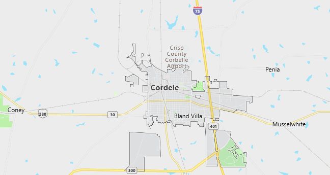
Moving to Cordele, Georgia
Cordele, the county seat of Crisp County, was founded in 1888. Also known as the “Watermelon Capital of the World”, Cordele was named for the eldest daughter of Colonel Samuel Hawkins. Col. Hawkins was president of the Savannah, Americus and Montgomery Railroads.
In November 1864, the area that is now Cordele served as the temporary capital of Georgia. During the last days of the Confederacy, Georgia’s war governor, Joseph E. Brown, used his rural farmhouse to escape Sherman’s “March to the Sea”. The farmhouse, called “Dooly County Place” served as the unofficial capital for only a few days. After the war, the farmhouse was sold for $3,500.
The farmhouse was replaced in 1890 by the Suwanee Hotel, which was destroyed by fire November 19, 1994. It has been rebuilt and is still located in downtown Cordele. It now houses various businesses and private apartments.
Each July, Cordele holds the annual Watermelon Festival, along with many other events. The Georgia Veteran’s Memorial Museum displays the history of war and the Georgian soldiers who fought so proudly.
Population: 11,608. Estimated population in July 2024: 11,493 (-1.0% change)
Males: 5,221 (45.0%), Females: 6,387 (55.0%)
Crisp County
Zip codes: 31015.
Demographics
Median resident age: 31.2 years
Median household income: $17,615
Median house value: $63,200
Population by Race
Races in Cordele:
- Black (65.0%)
- White Non-Hispanic (31.6%)
- Hispanic (1.9%)
- Other race (1.2%)
- Two or more races (0.9%)
- Asian Indian (0.6%)
Ancestries: United States (11.8%), Irish (3.5%), English (3.3%), German (2.1%), Subsaharan African (2.0%), Scotch-Irish (1.6%).
Elevation: 319 feet
Land area: 9.5 square miles

Population by Education
For population 25 years and over in Cordele
- High school or higher: 60.8%
- Bachelor’s degree or higher: 11.7%
- Graduate or professional degree: 3.7%
- Unemployed: 11.5%
- Mean travel time to work: 17.8 minutes
For population 15 years and over in Cordele city
- Never married: 34.3%
- Now married: 38.5%
- Separated: 5.0%
- Widowed: 11.7%
- Divorced: 10.4%
1.7% Foreign born
Population change in the 1990s: +570 (+5.2%).
Hospitals
Hospital/medical center in Cordele:
- CRISP REGIONAL HOSPITAL (902 7TH STREET NORTH)
Other hospitals/medical centers near Cordele:
- FLINT RIVER COMMUNITY HOSPITAL (about 27 miles; MONTEZUMA, GA)
- TAYLOR REGIONAL HOSPITAL (about 30 miles; HAWKINSVILLE, GA)
- PHOEBE WORTH MEDICAL CENTER (about 30 miles; SYLVESTER, GA)
Airports
Airports certified for carrier operations nearest to Cordele:
- SOUTHWEST GEORGIA REGIONAL (about 41 miles; ALBANY, GA; Abbreviation: ABY)
- ROBINS AFB (about 48 miles; WARNER ROBINS, GA; Abbreviation: WRB)
- MIDDLE GEORGIA REGIONAL (about 51 miles; MACON, GA; Abbreviation: MCN)
Other public-use airports nearest to Cordele:
- CRISP COUNTY-CORDELE (about 2 miles; CORDELE, GA; Abbreviation: CKF)
- TURNER COUNTY (about 23 miles; ASHBURN, GA; Abbreviation: 75J)
- DR. C P SAVAGE SR. (about 28 miles; MONTEZUMA, GA; Abbreviation: 53A)
Colleges and Universities
Colleges/universities with over 2000 students nearest to Cordele:
- ALBANY STATE UNIVERSITY (about 36 miles; ALBANY, GA; Full-time enrollment: 2,996)
- FORT VALLEY STATE UNIVERSITY (about 42 miles; FT VALLEY, GA; Full-time enrollment: 2,233)
- MACON STATE COLLEGE (about 58 miles; MACON, GA; Full-time enrollment: 2,557)
- CENTRAL GEORGIA TECHNICAL COLLEGE (about 58 miles; MACON, GA; Full-time enrollment: 2,383)
- MERCER UNIVERSITY (about 61 miles; MACON, GA; Full-time enrollment: 5,859)
- GORDON COLLEGE (about 80 miles; BARNESVILLE, GA; Full-time enrollment: 2,263)
- VALDOSTA STATE UNIVERSITY (about 84 miles; VALDOSTA, GA; Full-time enrollment: 7,157)
Schools
Public high school in Cordele:
- CRISP COUNTY HIGH SCHOOL (Students: 1,134; Location: 2402 COUGAR ALLEY; Grades: 09 – 12)
Private high school in Cordele:
- CRISP ACADEMY (Students: 229; Location: 150 CRIST ACADEMY DR; Grades: PK – 12)
Biggest public primary/middle schools in Cordele:
- CRISP COUNTY MIDDLE SCHOOL (Students: 995; Location: 1116 24TH AVENUE EAST; Grades: 06 – 08)
- BLACKSHEAR TRAIL ELEMENTARY SCHOOL (Students: 690; Location: 1001 BLACKSHEAR ROAD; Grades: PK – 02)
- SOUTHWESTERN ELEMENTARY SCHOOL (Students: 593; Location: 1001 24TH AVENUE WEST; Grades: 03 – 05)
- J. S. PATE ELEMENTARY SCHOOL (Students: 560; Location: 802 24TH AVENUE EAST; Grades: KG – 02)
- A. S. CLARK ELEMENTARY SCHOOL (Students: 416; Location: 401 15TH STREET NORTH; Grades: 03 – 05)
- FLINT AREA PSYCHOEDUCATIONAL PROGRAM (Location: P. O. BOX 729; Grades: 00 – 00)
- FLINT AREA PSYCHOEDUCATIONAL PROGRAM (Location: P. O. BOX 729; Grades: 00 – 00)
- FLINT AREA PSYCHOEDUCATIONAL PROGRAM (Location: P. O. BOX 729; Grades: 00 – 00)
- FLINT AREA PSYCHOEDUCATIONAL PROGRAM (Location: P. O. BOX 729; Grades: 00 – 00)
- FLINT AREA PSYCHOEDUCATIONAL PROGRAM (Location: 500 14TH AVENUE EAST; Grades: 00 – 00)
