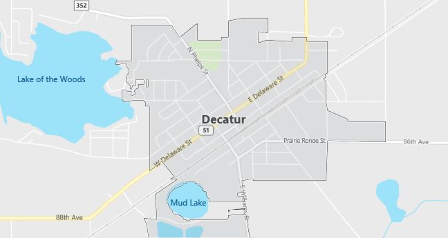
Moving to Decatur, Michigan
Population: 1,838. Estimated population in July 2024: 1,890 (+2.8% change)
Males: 882 (48.0%), Females: 956 (52.0%)
Van Buren County
Zip code: 49045
Demographics
Median resident age: 34.5 years
Median household income: $30,550
Median house value: $65,800
Population by Race
Races in Decatur:
- White Non-Hispanic (86.0%)
- Black (5.8%)
- Hispanic (4.1%)
- Two or more races (3.0%)
- American Indian (2.5%)
- Other race (1.8%)
Ancestries: German (24.2%), Irish (13.9%), Dutch (12.0%), Polish (6.9%), English (6.6%), United States (6.6%).
Elevation: 780 feet
Land area: 1.1 square miles

Population by Education
For population 25 years and over in Decatur
- High school or higher: 73.0%
- Bachelor’s degree or higher: 7.9%
- Graduate or professional degree: 3.8%
- Unemployed: 7.9%
- Mean travel time to work: 22.1 minutes
For population 15 years and over in Decatur village
- Never married: 26.8%
- Now married: 44.7%
- Separated: 2.2%
- Widowed: 10.7%
- Divorced: 15.7%
1.7% Foreign born
Population change in the 1990s: +57 (+3.2%).
Hospitals
Hospitals/medical centers near Decatur:
- LAKEVIEW COMMUNITY HOSPITAL (about 10 miles; PAW PAW, MI)
- LEE MEMORIAL HOSPITAL (about 13 miles; DOWAGIAC, MI)
- COMMUNITY HOSPITAL (about 21 miles; WATERVLIET, MI)
Airports
Airports certified for carrier operations nearest to Decatur:
- ELKHART MUNI (about 28 miles; ELKHART, IN; Abbreviation: EKM)
- KALAMAZOO/BATTLE CREEK INTERNATIONAL (about 31 miles; KALAMAZOO, MI; Abbreviation: AZO)
- SOUTH BEND REGIONAL (about 37 miles; SOUTH BEND, IN; Abbreviation: SBN)
Other public-use airports nearest to Decatur:
- ALMENA (about 13 miles; PAW PAW, MI; Abbreviation: 2C5)
- DOWAGIAC MUNICIPAL (about 14 miles; DOWAGIAC, MI; Abbreviation: C91)
- PRAIRIE RONDE (about 19 miles; SCHOOLCRAFT, MI; Abbreviation: P97)
Amtrak stations near Decatur:
- 13 miles: DOWAGIAC (100 RAILROAD DR.). Services: enclosed waiting area, public restrooms, public payphones, free short-term parking, free long-term parking, call for car rental service.
- 17 miles: BANGOR (541 RAILROAD ST.). Services: enclosed waiting area, public payphones, free short-term parking, free long-term parking.
Colleges and Universities
Colleges/universities with over 2000 students nearest to Decatur:
- KALAMAZOO VALLEY COMMUNITY COLLEGE (about 23 miles; KALAMAZOO, MI; Full-time enrollment: 5,017)
- WESTERN MICHIGAN UNIVERSITY (about 28 miles; KALAMAZOO, MI; Full-time enrollment: 23,132)
- UNIVERSITY OF NOTRE DAME (about 34 miles; NOTRE DAME, IN; Full-time enrollment: 10,633)
- INDIANA UNIVERSITY-SOUTH BEND (about 42 miles; SOUTH BEND, IN; Full-time enrollment: 4,725)
- HOPE COLLEGE (about 46 miles; HOLLAND, MI; Full-time enrollment: 2,918)
- ANDREWS UNIVERSITY (about 52 miles; BERRIEN SPRINGS, MI; Full-time enrollment: 2,342)
- KELLOGG COMMUNITY COLLEGE (about 56 miles; BATTLE CREEK, MI; Full-time enrollment: 2,824)
Schools
Public high schools in Decatur:
- DECATUR HIGH SCHOOL (Students: 306; Location: 110 CEDAR STREET; Grades: 09 – 12)
- DECATUR ALTERNATIVE CHOICE SCHOOL (Students: 23; Location: 312 SCHOOL STREET; Grades: 09 – 12)
Public primary/middle schools in Decatur:
- DAVIS ELEMENTARY SCHOOL (Students: 471; Location: 409 N. PHELPS STREET; Grades: PK – 04)
- DECATUR MIDDLE SCHOOL (Students: 355; Location: 405 N. PHELPS STREET; Grades: 05 – 08)
Libraries
Library in Decatur:
- VAN BUREN DISTRICT LIBRARY (Operating income: $1,415,190; Location: 200 NORTH PHELPS STREET; 147,551 books; 4,803 audio materials; 5,999 video materials; 415 serial subscriptions)
