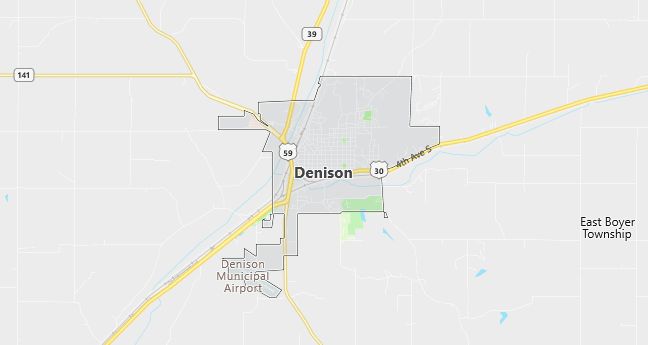
Moving to Denison, Iowa
Population: 7,339. Estimated population in July 2024: 7,374 (+0.5% change)
Males: 3,581 (48.8%), Females: 3,758 (51.2%)
Crawford County
Zip code: 51442
Demographics
Median resident age: 35.3 years
Median household income: $33,187
Median house value: $72,500
Population by Race
Races in Denison:
- White Non-Hispanic (79.5%)
- Hispanic (17.4%)
- Other race (9.0%)
- Black (1.6%)
- Two or more races (1.2%)
- American Indian (0.7%)
(Total can be greater than 100% because Hispanics could be counted in other races)
Ancestries: German (41.1%), Irish (11.1%), United States (8.8%), Danish (5.6%), English (4.1%), Norwegian (3.9%).
Land area: 6.2 square miles

Population by Education
For population 25 years and over in Denison
- High school or higher: 73.5%
- Bachelor’s degree or higher: 13.6%
- Graduate or professional degree: 3.2%
- Unemployed: 4.6%
- Mean travel time to work: 11.1 minutes
For population 15 years and over in Denison city
- Never married: 26.1%
- Now married: 53.6%
- Separated: 1.5%
- Widowed: 10.6%
- Divorced: 8.2%
12.6% Foreign born (11.9% Latin America).
Population change in the 1990s: +718 (+10.8%).
Hospitals
Hospital/medical center in Denison:
- CRAWFORD COUNTY MEMORIAL HOSPITAL (2020 FIRST AVE SOUTH)
Other hospitals/medical centers near Denison:
- MANNING REGIONAL HEALTHCARE CE (about 21 miles; MANNING, IA)
- HORN MEMORIAL HOSPITAL (about 24 miles; IDA GROVE, IA)
- SHELBY COUNTY MYRTUE MEMORIAL HOSPITAL (about 27 miles; HARLAN, IA)
Airports
Airports certified for carrier operations nearest to Denison:
- EPPLEY AIRFIELD (about 62 miles; OMAHA, NE; Abbreviation: OMA)
- SIOUX GATEWAY/COL. BUD DAY FIELD (about 77 miles; SIOUX CITY, IA; Abbreviation: SUX)
- FORT DODGE REGIONAL (about 89 miles; FORT DODGE, IA; Abbreviation: FOD)
Other public-use airports nearest to Denison:
- DENISON MUNI (about 3 miles; DENISON, IA; Abbreviation: DNS)
- IDA GROVE MUNI (about 22 miles; IDA GROVE, IA; Abbreviation: IDG)
- WALL LAKE MUNI (about 25 miles; WALL LAKE, IA; Abbreviation: 3Y0)
Colleges and Universities
College/University in Denison:
- DENISON AVIATION INC (Location: MUNICIPAL AIRPORT; Private, for-profit)
Colleges and Universities
Colleges/universities with over 2000 students nearest to Denison:
- BUENA VISTA UNIVERSITY (about 45 miles; STORM LAKE, IA; Full-time enrollment: 2,524)
- IOWA WESTERN COMMUNITY COLLEGE (about 60 miles; COUNCIL BLUFFS, IA; Full-time enrollment: 2,840)
- METROPOLITAN COMMUNITY COLLEGE AREA (about 66 miles; OMAHA, NE; Full-time enrollment: 6,175)
- WESTERN IOWA TECH COMMUNITY COLLEGE (about 72 miles; SIOUX CITY, IA; Full-time enrollment: 2,639)
- BELLEVUE UNIVERSITY (about 72 miles; BELLEVUE, NE; Full-time enrollment: 2,723)
- UNIVERSITY OF NEBRASKA AT OMAHA (about 76 miles; OMAHA, NE; Full-time enrollment: 10,150)
- CREIGHTON UNIVERSITY (about 76 miles; OMAHA, NE; Full-time enrollment: 5,806)
Schools
Public high school in Denison:
- DENISON HIGH SCHOOL (Students: 694; Location: 819 N 16TH ST; Grades: 09 – 12)
Public primary/middle schools in Denison:
- DENISON ELEMENTARY SCHOOL (Students: 719; Location: 38 N 20TH ST; Grades: PK – 05)
- DENISON MIDDLE SCHOOL (Students: 389; Location: 1515 E BROADWAY; Grades: 06 – 08)
Private primary/middle schools in Denison:
- ZION LUTHERAN SCHOOL (Students: 204; Location: 1004 1ST AVE SO; Grades: PK – 8)
- ST ROSE OF LIMA SCHOOL (Students: 87; Location: 1012 2ND AVE SO; Grades: KG – 6)
Libraries
Library in Denison:
- NORELIUS COMMUNITY LIBRARY (Operating income: $183,649; Location: 1403 1ST AVE SOUTH; 43,974 books; 1,999 audio materials; 1,286 video materials; 185 serial subscriptions)
