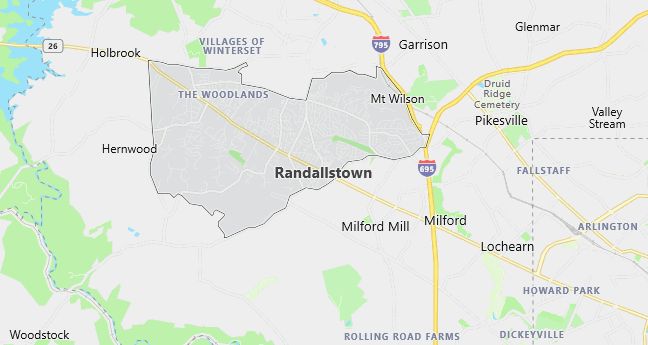
Moving to Randallstown, Maryland
Population: 30,870
Males: 14,098 (45.7%), Females: 16,772 (54.3%)
Baltimore County
Zip code: 21133
Demographics
Median resident age: 37.0 years
Median household income: $58,686
Median house value: $125,300
Population by Race
Races in Randallstown:
- Black (72.1%)
- White Non-Hispanic (22.7%)
- Two or more races (1.7%)
- Hispanic (1.5%)
- Asian Indian (0.9%)
- American Indian (0.8%)
- Other race (0.5%)
Ancestries: Subsaharan African (5.2%), German (4.2%), United States (2.5%), West Indian (2.5%), Irish (2.4%), Russian (2.3%).
Elevation: 560 feet
Land area: 10.3 square miles

Population by Education
For population 25 years and over in Randallstown
- High school or higher: 87.5%
- Bachelor’s degree or higher: 33.0%
- Graduate or professional degree: 13.4%
- Unemployed: 4.7%
- Mean travel time to work: 32.8 minutes
For population 15 years and over in Randallstown CDP
- Never married: 29.7%
- Now married: 50.2%
- Separated: 3.5%
- Widowed: 7.5%
- Divorced: 9.1%
7.9% Foreign born (2.3% Latin America, 2.0% Africa, 2.0% Asia, 1.4% Europe).
Hospitals
Hospital/medical center in Randallstown:
- NORTHWEST HOSPITAL CENTER (5401 OLD COURT RD)
Other hospitals/medical centers near Randallstown:
- JAMES LAWRENCE KERNAN HOSPITAL INC (about 7 miles; BALTIMORE, MD)
- SPRING GROVE HOSPITAL CENTER (about 8 miles; CATONSVILLE, MD)
- LEVINDALE HEBREW GERI CTR (about 9 miles; BALTIMORE, MD)
Airports
Airports certified for carrier operations nearest to Randallstown:
- BALTIMORE-WASHINGTON INTL (about 17 miles; BALTIMORE, MD; Abbreviation: BWI)
- RONALD REAGAN WASHINGTON NATIONAL (about 40 miles; WASHINGTON, DC; Abbreviation: DCA)
- ANDREWS AFB (about 40 miles; CAMP SPRINGS, MD; Abbreviation: ADW)
Other public-use airports nearest to Randallstown:
- HOBY WOLF (about 9 miles; ELDERSBURG, MD; Abbreviation: 1W5)
- CLEARVIEW AIRPARK (about 17 miles; WESTMINSTER, MD; Abbreviation: 2W2)
- TIPTON (about 21 miles; FORT MEADE(ODENTON), MD; Abbreviation: FME)
Amtrak stations near Randallstown:
- 14 miles: BALTIMORE (1500 N. CHARLES ST.). Services: ticket office, fully wheelchair accessible, enclosed waiting area, public restrooms, public payphones, full-service food facilities, snack bar, vending machines, ATM, paid short-term parking, paid long-term parking, call for car rental service, taxi stand, public transit connection.
- 15 miles: BWI AIRPORT RAIL STATION (BALTIMORE, AMTRAK WAY). Services: ticket office, fully wheelchair accessible, enclosed waiting area, public restrooms, public payphones, snack bar, ATM, paid short-term parking, paid long-term parking, call for car rental service, call for taxi service, public transit connection.
Colleges and Universities
Colleges/universities with over 2000 students nearest to Randallstown:
- THE COMMUNITY COLLEGE OF BALTIMORE COUNTY (about 8 miles; CATONSVILLE, MD; Full-time enrollment: 10,141)
- BALTIMORE CITY COMMUNITY COLLEGE (about 9 miles; BALTIMORE, MD; Full-time enrollment: 3,227)
- COPPIN STATE COLLEGE (about 10 miles; BALTIMORE, MD; Full-time enrollment: 2,844)
- UNIVERSITY OF MARYLAND-BALTIMORE COUNTY (about 10 miles; BALTIMORE, MD; Full-time enrollment: 9,095)
- LOYOLA COLLEGE (about 12 miles; BALTIMORE, MD; Full-time enrollment: 4,859)
- HOWARD COMMUNITY COLLEGE (about 13 miles; COLUMBIA, MD; Full-time enrollment: 3,036)
- TOWSON UNIVERSITY (about 13 miles; TOWSON, MD; Full-time enrollment: 13,971)
Schools
Public high school in Randallstown:
- RANDALLSTOWN HIGH (Students: 1,507; Location: 4000 OFFUTT RD; Grades: 09 – 12)
Private high school in Randallstown:
- KINGSWAY ACADEMY (Students: 182; Location: 10712 MARRIOTTSVILLE RD; Grades: 1 – 12)
Public primary/middle schools in Randallstown:
- DEER PARK MIDDLE MAGNET SCHOOL (Students: 1,333; Location: 9830 WINANDS RD; Grades: 06 – 08)
- CHURCH LANE ELEMENTARY TECHNOLOGY (Students: 512; Location: 3820 FERNSIDE RD; Grades: PK – 05)
- HERNWOOD ELEMENTARY (Students: 450; Location: 9919 MARRIOTTSVILLE RD; Grades: PK – 05)
- RANDALLSTOWN ELEMENTARY (Students: 390; Location: 9013 LIBERTY RD; Grades: KG – 05)
Private primary/middle school in Randallstown:
- HOLY FAMILY ELEMENTARY SCHOOL (Students: 197; Location: 9535 LIBERTY ROAD; Grades: KG – 8)
