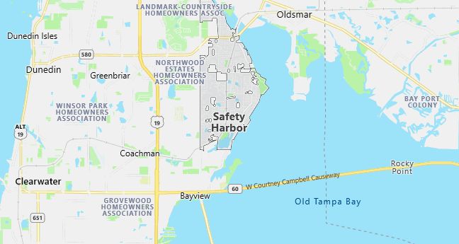
Moving to Safety Harbor, Florida
Population: 17,203. Estimated population in July 2024: 17,517 (+1.8% change)
Males: 8,197 (47.6%), Females: 9,006 (52.4%)
Pinellas County
Zip code: 34695
Demographics
Median resident age: 42.2 years
Median household income: $51,378
Median house value: $134,500
Population by Race
Races in Safety Harbor:
- White Non-Hispanic (89.5%)
- Black (4.1%)
- Hispanic (3.7%)
- Two or more races (1.2%)
- American Indian (0.6%)
Ancestries: German (19.2%), Irish (16.1%), English (12.4%), Italian (9.6%), United States (7.6%), Polish (5.2%).
Elevation: 14 feet
Land area: 4.9 square miles

Population by Education
For population 25 years and over in Safety Harbor
- High school or higher: 89.5%
- Bachelor’s degree or higher: 34.1%
- Graduate or professional degree: 11.8%
- Unemployed: 3.1%
- Mean travel time to work: 25.0 minutes
For population 15 years and over in Safety Harbor city
- Never married: 18.8%
- Now married: 60.3%
- Separated: 1.0%
- Widowed: 8.2%
- Divorced: 11.6%
7.3% Foreign born (3.3% Europe, 1.5% Latin America, 1.4% Asia, 1.0% North America).
Population change in the 1990s: +697 (+4.2%).
Hospitals
Hospital/medical center in Safety Harbor:
- MEASE HOSPITAL COUNTRYSIDE (3231 MCMULLEN BOOTH RD)
Other hospitals/medical centers near Safety Harbor:
- WINDMOOR HEALTHCARE OF CLEARWATER (about 6 miles; CLEARWATER, FL)
- MORTON PLANT HOSPITAL (about 7 miles; CLEARWATER, FL)
- EDWARD WHITE HOSPITAL (about 7 miles; SAINT PETERSBURG, FL)
Airports
Airports certified for carrier operations nearest to Safety Harbor:
- ST PETERSBURG-CLEARWATER INTL (about 8 miles; ST PETERSBURG-CLEARWATER, FL; Abbreviation: PIE)
- TAMPA INTL (about 13 miles; TAMPA, FL; Abbreviation: TPA)
- MAC DILL AFB (about 18 miles; TAMPA, FL; Abbreviation: MCF)
Other public-use airports nearest to Safety Harbor:
- CLEARWATER AIR PARK (about 5 miles; CLEARWATER, FL; Abbreviation: CLW)
- ALBERT WHITTED (about 19 miles; ST PETERSBURG, FL; Abbreviation: SPG)
- PETER O KNIGHT (about 20 miles; TAMPA, FL; Abbreviation: TPF)
Amtrak stations near Safety Harbor:
- 4 miles: CLEARWATER (20967 U.S. 19) – Bus Station
- 10 miles: TARPON SPRINGS (2337 U.S. 19) – Bus Station
- 12 miles: PINELLAS PARK (PARK BLVD. AT U.S. 19) – Bus Station. Services: ticket office, enclosed waiting area, public restrooms, public payphones, full-service food facilities, free short-term parking, call for car rental service, call for taxi service, public transit connection.
Colleges and Universities
Colleges/universities with over 2000 students nearest to Safety Harbor:
- HILLSBOROUGH COMMUNITY COLLEGE (about 17 miles; TAMPA, FL; Full-time enrollment: 9,630)
- UNIVERSITY OF TAMPA (about 17 miles; TAMPA, FL; Full-time enrollment: 2,963)
- UNIVERSITY OF SOUTH FLORIDA (about 20 miles; TAMPA, FL; Full-time enrollment: 26,221)
- PASCO-HERNANDO COMMUNITY COLLEGE (about 21 miles; NEW PORT RICHEY, FL; Full-time enrollment: 2,868)
- SAINT LEO UNIVERSITY (about 38 miles; ST LEO, FL; Full-time enrollment: 6,597)
- MANATEE COMMUNITY COLLEGE (about 40 miles; BRADENTON, FL; Full-time enrollment: 4,539)
- TRAVIS TECHNICAL CENTER (about 52 miles; LAKELAND, FL; Full-time enrollment: 2,057)
Public primary/middle schools in Safety Harbor:
- SAFETY HARBOR MIDDLE SCHOOL (Students: 1,462; Location: 125 7TH STREET, N; Grades: 06 – 08)
- SAFETY HARBOR ELEMENTARY SCHOOL (Students: 599; Location: 535 5TH AVENUE, N; Grades: KG – 05)
- SAFETY HARBOR SECONDARY SCHOOL (Students: 37; Location: 675 ELM STREET, N; Grades: 06 – 12)
